Treillières geodata
Treillières (Pays de la Loire) is a populated place; located in France in Europe/Paris (GMT+2) time zone. With population of 6,572 people, there are 1503 cities with bigger population in this country. Compared to other cities in France, 51.1% of cities are located further ↑North; 93.1% of cities are located further →East and 78.6% of cities have higher elevation than Treillières. Note1
Administrative division(s):
- Level 1: Pays de la Loire
- Level 2: Loire-Atlantique
- Level 3: Arrondissement of Châteaubriant-Ancenis
- Level 4: Treillières


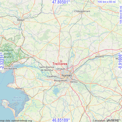
Treillières GPS coordinates[2]
47° 19' 50.16" North, 1° 37' 9.048" West
| Map corner | latitude | longitude |
|---|---|---|
| Upper-left | 47.80501°, | -2.32231° |
| Center: | 47.3306°, | -1.61918° |
| Lower-right: | 46.85189°, | -0.91606° |
| Map W x H: | 106×106 km | = 65.9×65.9mi |
| max Lat: | 51.07786° ⇑51.1% North |
| Treillières: | 47.3306° |
| min Lat: | ⇓48.9% South 41.3874° |
| min Long | Treillières | max Long |
| -5.08615° | -1.61918° | 9.52242° |
| W 6.9%⇐ | ⇒93.1% E |
Elevation
Elevation of Treillières is 58 m = 190 ft, and this is 135.7 m = 445 ft below average elevation for this country.
| Max E: |
2333 m = 7654 ft | 78.6% |
| Avg. | 193.7 m = 635 ft | |
| Treillières | 58 m = 190 ft | |
Min E: |
-1 m = -3 ft | 21.4% |
See also: France elevation on elevation.city.
Geographical zone
Treillières is located in North temperate zone (between Tropic of Cancer and the Arctic Circle). Distance of this North polar circle is 2138.5 km =1328.8 mi to North.| Distance of | km | miles | from Treillières |
|---|---|---|---|
| North Pole | 4744.4 | 2948 | to North |
| Arctic Circle | 2138.5 | 1328.8 | to North |
| Tropic Cancer | 2656.8 | 1650.9 | to South |
| Equator | 5262.7 | 3270.1 | to South |


Nearby cities:
15 places around Treillières: (largest is in red/bold)
• Carquefou
10.4 km =6.5 mi,  110°
110°
• Casson
7.9 km =4.9 mi,  36°
36°
• Héric
9.6 km =6 mi,  344°
344°
• La Chapelle-sur-Erdre
6.3 km =3.9 mi,  127°
127°
• Le Temple-de-Bretagne
12.8 km =8 mi,  268°
268°
• Nantes
13.5 km =8.4 mi,  158°
158°
• Notre-Dame-des-Landes
8.8 km =5.5 mi,  309°
309°
• Orvault
6.6 km =4.1 mi,  181°
181°
• Petit-Mars
14.5 km =9 mi,  60°
60°
• Saint-Herblain
12.8 km =8 mi,  189°
189°
• Saint-Étienne-de-Montluc
13.6 km =8.5 mi,  243°
243°
• Sainte-Luce-sur-Loire
13.3 km =8.3 mi, 130°
• Sautron
8.5 km =5.3 mi,  207°
207°
• Sucé-sur-Erdre
6.5 km =4 mi,  87°
87°
• Vigneux-de-Bretagne
8.9 km =5.5 mi, 266°
Sources, notices
• [Note1] Compared only with cities in France existing in our database
• [Src1] Map data: © OpenStreetMap contributors (CC-BY-SA)
• [Src2] Other city data from geonames.org with taken over terms of usage.
• [Src3] Geographical zone / Annual Mean Temperature by Robert A. Rohde @ Wikipedia
