Nantes geodata
Nantes (Pays de la Loire) is a seat of a first-order administrative division; located in France in Europe/Paris (GMT+2) time zone. With population of 277,269 people, there are 5 cities with bigger population in this country. Compared to other cities in France, 52.7% of cities are located further ↑North; 92.6% of cities are located further →East and 94.4% of cities have higher elevation than Nantes. Note1
Administrative division(s):
- Level 1: Pays de la Loire
- Level 2: Loire-Atlantique
- Level 3: Arrondissement de Nantes
- Level 4: Nantes


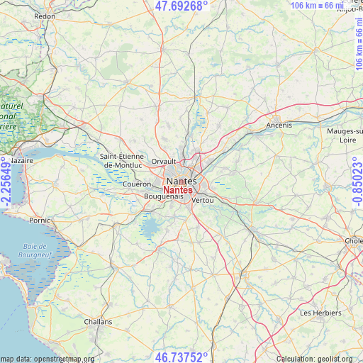
Nantes GPS coordinates[2]
47° 13' 2.1" North, 1° 33' 12.096" West
| Map corner | latitude | longitude |
|---|---|---|
| Upper-left | 47.69268°, | -2.25649° |
| Center: | 47.21725°, | -1.55336° |
| Lower-right: | 46.73752°, | -0.85023° |
| Map W x H: | 106.2×106.2 km | = 66×66mi |
| max Lat: | 51.07786° ⇑52.7% North |
| Nantes: | 47.21725° |
| min Lat: | ⇓47.3% South 41.3874° |
| min Long | Nantes | max Long |
| -5.08615° | -1.55336° | 9.52242° |
| W 7.4%⇐ | ⇒92.6% E |
Elevation
Elevation of Nantes is 19 m = 62 ft, and this is 174.7 m = 573 ft below average elevation for this country.
| Max E: |
2333 m = 7654 ft | 94.4% |
| Avg. | 193.7 m = 635 ft | |
| Nantes | 19 m = 62 ft | |
Min E: |
-1 m = -3 ft | 5.6% |
See also: Nantes elevation on elevation.city.
Geographical zone
Nantes is located in North temperate zone (between Tropic of Cancer and the Arctic Circle). Distance of this North polar circle is 2151.1 km =1336.6 mi to North.| Distance of | km | miles | from Nantes |
|---|---|---|---|
| North Pole | 4757 | 2955.9 | to North |
| Arctic Circle | 2151.1 | 1336.6 | to North |
| Tropic Cancer | 2644.1 | 1643 | to South |
| Equator | 5250.1 | 3262.3 | to South |


Nearby cities:
15 places around Nantes: (largest is in red/bold)
• Basse-Goulaine
6.5 km =4 mi,  95°
95°
• Bouguenais
6.8 km =4.2 mi,  229°
229°
• Carquefou
10.2 km =6.3 mi,  27°
27°
• Haute-Goulaine
9.6 km =6 mi, 102°
• Indre
8.8 km =5.5 mi,  257°
257°
• La Chapelle-sur-Erdre
8.7 km =5.4 mi,  0°
0°
• Les Sorinières
7.9 km =4.9 mi,  166°
166°
• Orvault
7.9 km =4.9 mi,  319°
319°
• Rezé
4 km =2.5 mi,  175°
175°
• Saint-Herblain
7.2 km =4.5 mi,  270°
270°
• Saint-Sébastien-sur-Loire
3.9 km =2.4 mi,  105°
105°
• Sainte-Luce-sur-Loire
6.6 km =4.1 mi,  52°
52°
• Sautron
10.2 km =6.3 mi,  299°
299°
• Thouaré-sur-Loire
10.4 km =6.5 mi,  56°
56°
• Vertou
8.3 km =5.2 mi,  130°
130°
Sources, notices
• [Note1] Compared only with cities in France existing in our database
• [Src1] Map data: © OpenStreetMap contributors (CC-BY-SA)
• [Src2] Other city data from geonames.org with taken over terms of usage.
• [Src3] Geographical zone / Annual Mean Temperature by Robert A. Rohde @ Wikipedia
