Bandol geodata
Bandol (Provence-Alpes-Côte d'Azur) is a populated place; located in France in Europe/Paris (GMT+2) time zone. With population of 8,546 people, there are 1129 cities with bigger population in this country. Compared to other cities in France, 97.6% of cities are located further ↑North; 84.7% of cities are located further ←West and 69.2% of cities have higher elevation than Bandol. Note1
Administrative division(s):
- Level 1: Provence-Alpes-Côte d'Azur
- Level 2: Var
- Level 3: Arrondissement de Toulon
- Level 4: Bandol


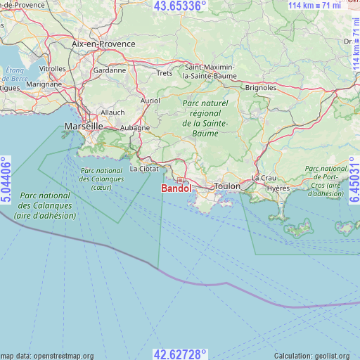
Bandol GPS coordinates[2]
43° 8' 32.892" North, 5° 44' 49.848" East
| Map corner | latitude | longitude |
|---|---|---|
| Upper-left | 43.65336°, | 5.04406° |
| Center: | 43.14247°, | 5.74718° |
| Lower-right: | 42.62728°, | 6.45031° |
| Map W x H: | 114.1×114.1 km | = 70.9×70.9mi |
| max Lat: | 51.07786° ⇑97.6% North |
| Bandol: | 43.14247° |
| min Lat: | ⇓2.4% South 41.3874° |
| min Long | Bandol | max Long |
| -5.08615° | 5.74718° | 9.52242° |
| W 84.7%⇐ | ⇒15.3% E |
Elevation
Elevation of Bandol is 80 m = 262 ft, and this is 113.7 m = 373 ft below average elevation for this country.
| Max E: |
2333 m = 7654 ft | 69.2% |
| Avg. | 193.7 m = 635 ft | |
| Bandol | 80 m = 262 ft | |
Min E: |
-1 m = -3 ft | 30.8% |
See also: France elevation on elevation.city.
Geographical zone
Bandol is located in North temperate zone (between Tropic of Cancer and the Arctic Circle). Distance of this Northern Tropic circle is 2191.1 km =1361.5 mi to South.| Distance of | km | miles | from Bandol |
|---|---|---|---|
| North Pole | 5210.1 | 3237.4 | to North |
| Arctic Circle | 2604.2 | 1618.2 | to North |
| Tropic Cancer | 2191.1 | 1361.5 | to South |
| Equator | 4797 | 2980.7 | to South |


Nearby cities:
15 places around Bandol: (largest is in red/bold)
• Ceyreste
12.4 km =7.7 mi,  309°
309°
• Cuges-les-Pins
15.3 km =9.5 mi,  345°
345°
• La Ciotat
12.1 km =7.5 mi,  287°
287°
• La Seyne-sur-Mer
11.5 km =7.1 mi,  112°
112°
• Le Beausset
7.7 km =4.8 mi,  35°
35°
• Le Castellet
7.1 km =4.4 mi,  19°
19°
• Le Revest-les-Eaux
15 km =9.3 mi,  75°
75°
• Ollioules
8.2 km =5.1 mi,  92°
92°
• Roquefort-la-Bédoule
17.4 km =10.8 mi, 312°
• Saint-Cyr-sur-Mer
5.6 km =3.5 mi,  318°
318°
• Saint-Mandrier-sur-Mer
16.4 km =10.2 mi,  115°
115°
• Sanary-sur-Mer
5.1 km =3.2 mi, 119°
• Six-Fours-les-Plages
8.4 km =5.2 mi,  131°
131°
• Toulon
14.8 km =9.2 mi,  97°
97°
• Évenos
8.4 km =5.2 mi,  73°
73°
Sources, notices
• [Note1] Compared only with cities in France existing in our database
• [Src1] Map data: © OpenStreetMap contributors (CC-BY-SA)
• [Src2] Other city data from geonames.org with taken over terms of usage.
• [Src3] Geographical zone / Annual Mean Temperature by Robert A. Rohde @ Wikipedia
