Salavas geodata
Salavas (Auvergne-Rhône-Alpes) is a populated place; located in France in Europe/Paris (GMT+2) time zone. With population of 536 people, there are 14480 cities with bigger population in this country. Compared to other cities in France, 84.3% of cities are located further ↑North; 71.2% of cities are located further ←West and 60% of cities have higher elevation than Salavas. Note1
Administrative division(s):
- Level 1: Auvergne-Rhône-Alpes
- Level 2: Département de l'Ardèche
- Level 3: Arrondissement de Largentière
- Level 4: Salavas


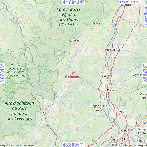
Salavas GPS coordinates[2]
44° 23' 38.688" North, 4° 22' 45.336" East
| Map corner | latitude | longitude |
|---|---|---|
| Upper-left | 44.89434°, | 3.67613° |
| Center: | 44.39408°, | 4.37926° |
| Lower-right: | 43.88951°, | 5.08238° |
| Map W x H: | 111.7×111.7 km | = 69.4×69.4mi |
| max Lat: | 51.07786° ⇑84.3% North |
| Salavas: | 44.39408° |
| min Lat: | ⇓15.7% South 41.3874° |
| min Long | Salavas | max Long |
| -5.08615° | 4.37926° | 9.52242° |
| W 71.2%⇐ | ⇒28.8% E |
Elevation
Elevation of Salavas is 102 m = 335 ft, and this is 91.7 m = 301 ft below average elevation for this country.
| Max E: |
2333 m = 7654 ft | 60% |
| Avg. | 193.7 m = 635 ft | |
| Salavas | 102 m = 335 ft | |
Min E: |
-1 m = -3 ft | 40% |
See also: France elevation on elevation.city.
Geographical zone
Salavas is located in North temperate zone (between Tropic of Cancer and the Arctic Circle). Distance of this Northern Tropic circle is 2330.2 km =1447.9 mi to South.| Distance of | km | miles | from Salavas |
|---|---|---|---|
| North Pole | 5070.9 | 3150.9 | to North |
| Arctic Circle | 2465 | 1531.7 | to North |
| Tropic Cancer | 2330.2 | 1447.9 | to South |
| Equator | 4936.2 | 3067.2 | to South |


Nearby cities:
15 places around Salavas: (largest is in red/bold)
• Barjac
9.9 km =6.2 mi,  192°
192°
• Berrias-et-Casteljau
14.6 km =9.1 mi,  257°
257°
• Grospierres
7.2 km =4.5 mi,  275°
275°
• Joyeuse
14.7 km =9.1 mi,  310°
310°
• Lablachère
15.2 km =9.4 mi,  300°
300°
• Lagorce
6.7 km =4.2 mi,  26°
26°
• Laurac-en-Vivarais
14.6 km =9.1 mi,  331°
331°
• Les Assions
16.6 km =10.3 mi, 280°
• Rosières
13.8 km =8.6 mi,  315°
315°
• Ruoms
7.2 km =4.5 mi,  335°
335°
• Saint-André-de-Cruzières
15.7 km =9.8 mi,  235°
235°
• Saint-Jean-de-Maruéjols-et-Avéjan
16.7 km =10.4 mi,  203°
203°
• Saint-Remèze
9.7 km =6 mi,  91°
91°
• Saint-Sauveur-de-Cruzières
14.5 km =9 mi,  223°
223°
• Vallon-Pont-d’Arc
1.8 km =1.1 mi,  39°
39°
Sources, notices
• [Note1] Compared only with cities in France existing in our database
• [Src1] Map data: © OpenStreetMap contributors (CC-BY-SA)
• [Src2] Other city data from geonames.org with taken over terms of usage.
• [Src3] Geographical zone / Annual Mean Temperature by Robert A. Rohde @ Wikipedia
