Rosières geodata
Rosières (Auvergne-Rhône-Alpes) is a populated place; located in France in Europe/Paris (GMT+2) time zone. With population of 1,044 people, there are 8506 cities with bigger population in this country. Compared to other cities in France, 83.7% of cities are located further ↑North; 70.2% of cities are located further ←West and 54.7% of cities have lower elevation than Rosières. Note1
Administrative division(s):
- Level 1: Auvergne-Rhône-Alpes
- Level 2: Département de l'Ardèche
- Level 3: Arrondissement de Largentière
- Level 4: Rosières


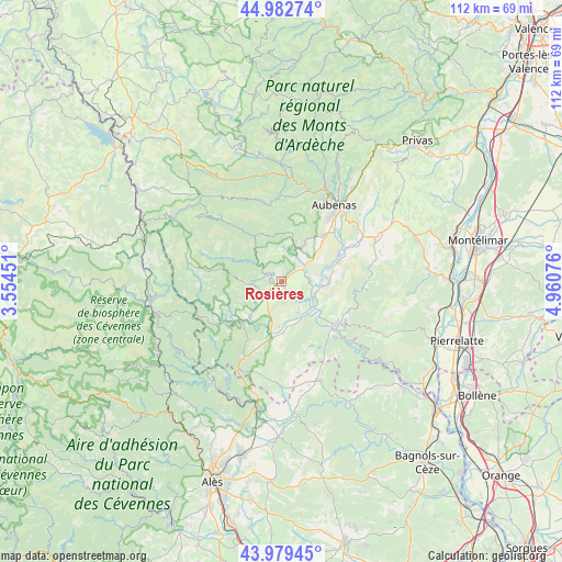
Rosières GPS coordinates[2]
44° 28' 59.7" North, 4° 15' 27.468" East
| Map corner | latitude | longitude |
|---|---|---|
| Upper-left | 44.98274°, | 3.55451° |
| Center: | 44.48325°, | 4.25763° |
| Lower-right: | 43.97945°, | 4.96076° |
| Map W x H: | 111.6×111.6 km | = 69.3×69.3mi |
| max Lat: | 51.07786° ⇑83.7% North |
| Rosières: | 44.48325° |
| min Lat: | ⇓16.3% South 41.3874° |
| min Long | Rosières | max Long |
| -5.08615° | 4.25763° | 9.52242° |
| W 70.2%⇐ | ⇒29.8% E |
Elevation
Elevation of Rosières is 149 m = 489 ft, and this is 44.7 m = 147 ft below average elevation for this country.
| Max E: |
2333 m = 7654 ft | 45.3% |
| Avg. | 193.7 m = 635 ft | |
| Rosières | 149 m = 489 ft | |
Min E: |
-1 m = -3 ft | 54.7% |
See also: France elevation on elevation.city.
Geographical zone
Rosières is located in North temperate zone (between Tropic of Cancer and the Arctic Circle). Distance of this Northern Tropic circle is 2340.2 km =1454.1 mi to South.| Distance of | km | miles | from Rosières |
|---|---|---|---|
| North Pole | 5061 | 3144.8 | to North |
| Arctic Circle | 2455.1 | 1525.5 | to North |
| Tropic Cancer | 2340.2 | 1454.1 | to South |
| Equator | 4946.1 | 3073.4 | to South |


Nearby cities:
15 places around Rosières: (largest is in red/bold)
• Berrias-et-Casteljau
13.7 km =8.5 mi,  199°
199°
• Chambonas
12.6 km =7.8 mi,  234°
234°
• Chassiers
8.1 km =5 mi,  22°
22°
• Grospierres
9.5 km =5.9 mi,  164°
164°
• Joyeuse
1.6 km =1 mi,  255°
255°
• Lablachère
4.1 km =2.5 mi,  237°
237°
• Lachapelle-sous-Aubenas
12.3 km =7.6 mi,  43°
43°
• Lagorce
13.3 km =8.3 mi,  107°
107°
• Largentière
7.2 km =4.5 mi, 23°
• Laurac-en-Vivarais
3.8 km =2.4 mi, 42°
• Les Assions
9.6 km =6 mi,  224°
224°
• Les Vans
13.2 km =8.2 mi, 228°
• Ruoms
7.5 km =4.7 mi,  116°
116°
• Salavas
13.8 km =8.6 mi,  135°
135°
• Vallon-Pont-d’Arc
13.7 km =8.5 mi,  128°
128°
Sources, notices
• [Note1] Compared only with cities in France existing in our database
• [Src1] Map data: © OpenStreetMap contributors (CC-BY-SA)
• [Src2] Other city data from geonames.org with taken over terms of usage.
• [Src3] Geographical zone / Annual Mean Temperature by Robert A. Rohde @ Wikipedia
