Saint-Remèze geodata
Saint-Remèze (Auvergne-Rhône-Alpes) is a populated place; located in France in Europe/Paris (GMT+2) time zone. With population of 589 people, there are 13496 cities with bigger population in this country. Compared to other cities in France, 84.3% of cities are located further ↑North; 72.1% of cities are located further ←West and 87.4% of cities have lower elevation than Saint-Remèze. Note1
Administrative division(s):
- Level 1: Auvergne-Rhône-Alpes
- Level 2: Département de l'Ardèche
- Level 3: Arrondissement de Largentière
- Level 4: Saint-Remèze


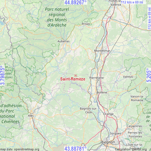
Saint-Remèze GPS coordinates[2]
44° 23' 32.64" North, 4° 30' 6.768" East
| Map corner | latitude | longitude |
|---|---|---|
| Upper-left | 44.89267°, | 3.79875° |
| Center: | 44.3924°, | 4.50188° |
| Lower-right: | 43.88781°, | 5.205° |
| Map W x H: | 111.7×111.7 km | = 69.4×69.4mi |
| max Lat: | 51.07786° ⇑84.3% North |
| Saint-Remèze: | 44.3924° |
| min Lat: | ⇓15.7% South 41.3874° |
| min Long | Saint-Remèze | max Long |
| -5.08615° | 4.50188° | 9.52242° |
| W 72.1%⇐ | ⇒27.9% E |
Elevation
Elevation of Saint-Remèze is 380 m = 1247 ft, and this is 186.3 m = 611 ft above average elevation for this country.
| Max E: |
2333 m = 7654 ft | 12.6% |
| Saint-Remèze | 380 m 1247 ft | |
| Avg. | 193.7 m = 635 ft | |
Min E: |
-1 m = -3 ft | 87.4% |
See also: France elevation on elevation.city.
Geographical zone
Saint-Remèze is located in North temperate zone (between Tropic of Cancer and the Arctic Circle). Distance of this Northern Tropic circle is 2330.1 km =1447.9 mi to South.| Distance of | km | miles | from Saint-Remèze |
|---|---|---|---|
| North Pole | 5071.1 | 3151 | to North |
| Arctic Circle | 2465.2 | 1531.8 | to North |
| Tropic Cancer | 2330.1 | 1447.9 | to South |
| Equator | 4936 | 3067.1 | to South |


Nearby cities:
15 places around Saint-Remèze: (largest is in red/bold)
• Barjac
15.2 km =9.4 mi,  231°
231°
• Bourg-Saint-Andéol
11.5 km =7.1 mi,  100°
100°
• Donzère
17.5 km =10.9 mi,  71°
71°
• Grospierres
16.9 km =10.5 mi,  273°
273°
• Lagorce
9.1 km =5.7 mi,  312°
312°
• Lapalud
17.6 km =10.9 mi,  122°
122°
• Pierrelatte
16.1 km =10 mi, 96°
• Ruoms
14.4 km =8.9 mi,  297°
297°
• Saint-Julien-de-Peyrolas
12.6 km =7.8 mi,  156°
156°
• Saint-Just-d'Ardèche
13.7 km =8.5 mi,  138°
138°
• Saint-Marcel-d'Ardèche
11.7 km =7.3 mi,  128°
128°
• Saint-Paulet-de-Caisson
16.5 km =10.3 mi,  152°
152°
• Salavas
9.7 km =6 mi, 271°
• Vallon-Pont-d’Arc
8.7 km =5.4 mi,  280°
280°
• Viviers
17.9 km =11.1 mi,  55°
55°
Sources, notices
• [Note1] Compared only with cities in France existing in our database
• [Src1] Map data: © OpenStreetMap contributors (CC-BY-SA)
• [Src2] Other city data from geonames.org with taken over terms of usage.
• [Src3] Geographical zone / Annual Mean Temperature by Robert A. Rohde @ Wikipedia
