Montescourt-Lizerolles geodata
Montescourt-Lizerolles (Hauts-de-France) is a populated place; located in France in Europe/Paris (GMT+2) time zone. With population of 1,543 people, there are 6040 cities with bigger population in this country. Compared to other cities in France, 91.8% of cities are located further ↓South; 61.4% of cities are located further ←West and 71% of cities have higher elevation than Montescourt-Lizerolles. Note1
Administrative division(s):
- Level 1: Hauts-de-France
- Level 2: Département de l'Aisne
- Level 3: Arrondissement de Saint-Quentin
- Level 4: Montescourt-Lizerolles
Current local time in Montescourt-Lizerolles:
01:43 PM, WednesdayDifference from your time zone: hours


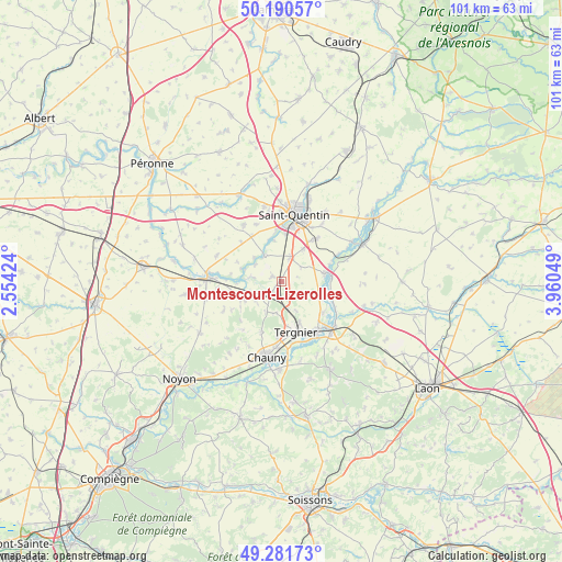
Montescourt-Lizerolles GPS coordinates[2]
49° 44' 17.808" North, 3° 15' 26.496" East
| Map corner | latitude | longitude |
|---|---|---|
| Upper-left | 50.19057°, | 2.55424° |
| Center: | 49.73828°, | 3.25736° |
| Lower-right: | 49.28173°, | 3.96049° |
| Map W x H: | 101.1×101.1 km | = 62.8×62.8mi |
| max Lat: | 51.07786° ⇑8.2% North |
| Montescourt-Lizerolles: | 49.73828° |
| min Lat: | ⇓91.8% South 41.3874° |
| min Long | Montescourt-Liz | max Long |
| -5.08615° | 3.25736° | 9.52242° |
| W 61.4%⇐ | ⇒38.6% E |
Elevation
Elevation of Montescourt-Lizerolles is 76 m = 249 ft, and this is 117.7 m = 386 ft below average elevation for this country.
| Max E: |
2333 m = 7654 ft | 71% |
| Avg. | 193.7 m = 635 ft | |
| Montescourt-Lizerolles | 76 m = 249 ft | |
Min E: |
-1 m = -3 ft | 29% |
See also: France elevation on elevation.city.
Geographical zone
Montescourt-Lizerolles is located in North temperate zone (between Tropic of Cancer and the Arctic Circle). Distance of this North polar circle is 1870.8 km =1162.5 mi to North.| Distance of | km | miles | from Montescourt-Lizerolles |
|---|---|---|---|
| North Pole | 4476.7 | 2781.7 | to North |
| Arctic Circle | 1870.8 | 1162.5 | to North |
| Tropic Cancer | 2924.5 | 1817.2 | to South |
| Equator | 5530.4 | 3436.4 | to South |


Nearby cities:
15 places around Montescourt-Lizerolles: (largest is in red/bold)
• Clastres
2 km =1.2 mi,  296°
296°
• Cugny
8.3 km =5.2 mi,  245°
245°
• Essigny-le-Grand
4.7 km =2.9 mi,  18°
18°
• Flavy-le-Martel
5.5 km =3.4 mi,  239°
239°
• Frières-Faillouël
5.7 km =3.5 mi,  190°
190°
• Grugies
8.3 km =5.2 mi,  5°
5°
• Itancourt
9.8 km =6.1 mi,  39°
39°
• Jussy
2.7 km =1.7 mi,  220°
220°
• Saint-Simon
5.8 km =3.6 mi,  278°
278°
• Seraucourt-le-Grand
5.8 km =3.6 mi,  329°
329°
• Tergnier
9.7 km =6 mi,  161°
161°
• Travecy
9.3 km =5.8 mi,  128°
128°
• Urvillers
6.9 km =4.3 mi,  33°
33°
• Vendeuil
7.3 km =4.5 mi,  110°
110°
• Villequier-Aumont
9.7 km =6 mi,  202°
202°
Sources, notices
• [Note1] Compared only with cities in France existing in our database
• [Src1] Map data: © OpenStreetMap contributors (CC-BY-SA)
• [Src2] Other city data from geonames.org with taken over terms of usage.
• [Src3] Geographical zone / Annual Mean Temperature by Robert A. Rohde @ Wikipedia
