Saint-Saud-Lacoussière geodata
Saint-Saud-Lacoussière (Nouvelle-Aquitaine) is a populated place; located in France in Europe/Paris (GMT+2) time zone. With population of 918 people, there are 9502 cities with bigger population in this country. Compared to other cities in France, 73.6% of cities are located further ↑North; 70.4% of cities are located further →East and 81.5% of cities have lower elevation than Saint-Saud-Lacoussière. Note1
Administrative division(s):
- Level 1: Nouvelle-Aquitaine
- Level 2: Dordogne
- Level 3: Arrondissement de Nontron
- Level 4: Saint-Saud-Lacoussière
Current local time in Saint-Saud-Lacoussière:
11:55 AM, SaturdayDifference from your time zone: hours


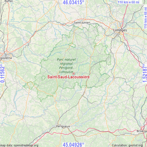
Saint-Saud-Lacoussière GPS coordinates[2]
45° 32' 37.896" North, 0° 49' 7.5" East
| Map corner | latitude | longitude |
|---|---|---|
| Upper-left | 46.03415°, | 0.11562° |
| Center: | 45.54386°, | 0.81875° |
| Lower-right: | 45.04926°, | 1.52187° |
| Map W x H: | 109.5×109.5 km | = 68×68mi |
| max Lat: | 51.07786° ⇑73.6% North |
| Saint-Saud-Lacoussière: | 45.54386° |
| min Lat: | ⇓26.4% South 41.3874° |
| min Long | Saint-Saud-Laco | max Long |
| -5.08615° | 0.81875° | 9.52242° |
| W 29.6%⇐ | ⇒70.4% E |
Elevation
Elevation of Saint-Saud-Lacoussière is 305 m = 1001 ft, and this is 111.3 m = 365 ft above average elevation for this country.
| Max E: |
2333 m = 7654 ft | 18.5% |
| Saint-Saud-Lacoussière | 305 m 1001 ft | |
| Avg. | 193.7 m = 635 ft | |
Min E: |
-1 m = -3 ft | 81.5% |
See also: France elevation on elevation.city.
Geographical zone
Saint-Saud-Lacoussière is located in North temperate zone (between Tropic of Cancer and the Arctic Circle). Distance of this North polar circle is 2337.2 km =1452.3 mi to North.| Distance of | km | miles | from Saint-Saud-Lacoussière |
|---|---|---|---|
| North Pole | 4943.1 | 3071.5 | to North |
| Arctic Circle | 2337.2 | 1452.3 | to North |
| Tropic Cancer | 2458.1 | 1527.4 | to South |
| Equator | 5064 | 3146.6 | to South |


Nearby cities:
15 places around Saint-Saud-Lacoussière: (largest is in red/bold)
• Abjat-sur-Bandiat
6.5 km =4 mi,  314°
314°
• Augignac
10.6 km =6.6 mi,  298°
298°
• Dournazac
11.8 km =7.3 mi,  40°
40°
• La Coquille
12.3 km =7.6 mi,  90°
90°
• Marval
9.4 km =5.8 mi,  349°
349°
• Mialet
6.7 km =4.2 mi,  84°
84°
• Milhac-de-Nontron
9 km =5.6 mi,  198°
198°
• Nontron
12.3 km =7.6 mi,  262°
262°
• Piégut-Pluviers
13.3 km =8.3 mi, 311°
• Saint-Estèphe
13.2 km =8.2 mi,  294°
294°
• Saint-Front-la-Rivière
10.7 km =6.6 mi,  221°
221°
• Saint-Jory-de-Chalais
8 km =5 mi,  127°
127°
• Saint-Martial-de-Valette
13.5 km =8.4 mi, 257°
• Saint-Pardoux-la-Rivière
7.9 km =4.9 mi,  225°
225°
• Villars
14.7 km =9.1 mi, 200°
Sources, notices
• [Note1] Compared only with cities in France existing in our database
• [Src1] Map data: © OpenStreetMap contributors (CC-BY-SA)
• [Src2] Other city data from geonames.org with taken over terms of usage.
• [Src3] Geographical zone / Annual Mean Temperature by Robert A. Rohde @ Wikipedia
