Abjat-sur-Bandiat geodata
Abjat-sur-Bandiat (Nouvelle-Aquitaine) is a populated place; located in France in Europe/Paris (GMT+2) time zone. With population of 662 people, there are 12351 cities with bigger population in this country. Compared to other cities in France, 72.8% of cities are located further ↑North; 70.9% of cities are located further →East and 77.4% of cities have lower elevation than Abjat-sur-Bandiat. Note1
Administrative division(s):
- Level 1: Nouvelle-Aquitaine
- Level 2: Dordogne
- Level 3: Arrondissement de Nontron
- Level 4: Abjat-sur-Bandiat


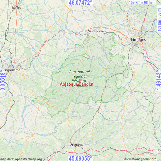
Abjat-sur-Bandiat GPS coordinates[2]
45° 35' 5.244" North, 0° 45' 29.916" East
| Map corner | latitude | longitude |
|---|---|---|
| Upper-left | 46.07472°, | 0.05518° |
| Center: | 45.58479°, | 0.75831° |
| Lower-right: | 45.09055°, | 1.46143° |
| Map W x H: | 109.4×109.4 km | = 68×68mi |
| max Lat: | 51.07786° ⇑72.8% North |
| Abjat-sur-Bandiat: | 45.58479° |
| min Lat: | ⇓27.2% South 41.3874° |
| min Long | Abjat-sur-Bandi | max Long |
| -5.08615° | 0.75831° | 9.52242° |
| W 29.1%⇐ | ⇒70.9% E |
Elevation
Elevation of Abjat-sur-Bandiat is 267 m = 876 ft, and this is 73.3 m = 240 ft above average elevation for this country.
| Max E: |
2333 m = 7654 ft | 22.6% |
| Abjat-sur-Bandiat | 267 m 876 ft | |
| Avg. | 193.7 m = 635 ft | |
Min E: |
-1 m = -3 ft | 77.4% |
See also: France elevation on elevation.city.
Geographical zone
Abjat-sur-Bandiat is located in North temperate zone (between Tropic of Cancer and the Arctic Circle). Distance of this North polar circle is 2332.6 km =1449.4 mi to North.| Distance of | km | miles | from Abjat-sur-Bandiat |
|---|---|---|---|
| North Pole | 4938.5 | 3068.6 | to North |
| Arctic Circle | 2332.6 | 1449.4 | to North |
| Tropic Cancer | 2462.6 | 1530.2 | to South |
| Equator | 5068.6 | 3149.5 | to South |


Nearby cities:
15 places around Abjat-sur-Bandiat: (largest is in red/bold)
• Augignac
4.6 km =2.9 mi,  276°
276°
• Busserolles
13.6 km =8.5 mi,  318°
318°
• Champniers-et-Reilhac
9.3 km =5.8 mi,  347°
347°
• Dournazac
13.1 km =8.1 mi,  69°
69°
• Marval
5.6 km =3.5 mi,  32°
32°
• Mialet
12.1 km =7.5 mi,  108°
108°
• Milhac-de-Nontron
13.2 km =8.2 mi,  172°
172°
• Nontron
9.7 km =6 mi,  230°
230°
• Piégut-Pluviers
6.8 km =4.2 mi,  308°
308°
• Saint-Estèphe
7.4 km =4.6 mi, 276°
• Saint-Front-la-Rivière
12.8 km =8 mi,  190°
190°
• Saint-Martial-de-Valette
11.3 km =7 mi, 228°
• Saint-Mathieu
13.5 km =8.4 mi,  0°
0°
• Saint-Pardoux-la-Rivière
10.1 km =6.3 mi, 185°
• Saint-Saud-Lacoussière
6.5 km =4 mi,  134°
134°
Sources, notices
• [Note1] Compared only with cities in France existing in our database
• [Src1] Map data: © OpenStreetMap contributors (CC-BY-SA)
• [Src2] Other city data from geonames.org with taken over terms of usage.
• [Src3] Geographical zone / Annual Mean Temperature by Robert A. Rohde @ Wikipedia
