Gometz-le-Châtel geodata
Gometz-le-Châtel (Île-de-France) is a populated place; located in France in Europe/Paris (GMT+2) time zone. With population of 1,954 people, there are 4899 cities with bigger population in this country. Compared to other cities in France, 72.7% of cities are located further ↓South; 55.3% of cities are located further →East and 53.9% of cities have lower elevation than Gometz-le-Châtel. Note1
Administrative division(s):
- Level 1: Île-de-France
- Level 2: Département de l'Essonne
- Level 3: Arrondissement de Palaiseau
- Level 4: Gometz-le-Châtel


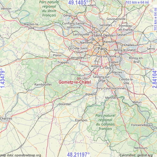
Gometz-le-Châtel GPS coordinates[2]
48° 40' 42.132" North, 2° 8' 16.512" East
| Map corner | latitude | longitude |
|---|---|---|
| Upper-left | 49.1405°, | 1.43479° |
| Center: | 48.67837°, | 2.13792° |
| Lower-right: | 48.21197°, | 2.84104° |
| Map W x H: | 103.2×103.2 km | = 64.1×64.1mi |
| max Lat: | 51.07786° ⇑27.3% North |
| Gometz-le-Châtel: | 48.67837° |
| min Lat: | ⇓72.7% South 41.3874° |
| min Long | Gometz-le-Chât | max Long |
| -5.08615° | 2.13792° | 9.52242° |
| W 44.7%⇐ | ⇒55.3% E |
Elevation
Elevation of Gometz-le-Châtel is 146 m = 479 ft, and this is 47.7 m = 156 ft below average elevation for this country.
| Max E: |
2333 m = 7654 ft | 46.1% |
| Avg. | 193.7 m = 635 ft | |
| Gometz-le-Châtel | 146 m = 479 ft | |
Min E: |
-1 m = -3 ft | 53.9% |
See also: France elevation on elevation.city.
Geographical zone
Gometz-le-Châtel is located in North temperate zone (between Tropic of Cancer and the Arctic Circle). Distance of this North polar circle is 1988.6 km =1235.7 mi to North.| Distance of | km | miles | from Gometz-le-Châtel |
|---|---|---|---|
| North Pole | 4594.5 | 2854.9 | to North |
| Arctic Circle | 1988.6 | 1235.7 | to North |
| Tropic Cancer | 2806.6 | 1743.9 | to South |
| Equator | 5412.5 | 3363.2 | to South |


Nearby cities:
15 places around Gometz-le-Châtel: (largest is in red/bold)
• Boullay-les-Troux
6.5 km =4 mi,  270°
270°
• Briis-sous-Forges
6.2 km =3.9 mi,  191°
191°
• Bures-sur-Yvette
3.4 km =2.1 mi,  45°
45°
• Forges-les-Bains
6 km =3.7 mi,  205°
205°
• Gif-sur-Yvette
0.6 km =0.4 mi,  328°
328°
• Gometz-la-Ville
1 km =0.6 mi,  224°
224°
• Janvry
3.5 km =2.2 mi,  161°
161°
• Les Molières
5.1 km =3.2 mi,  263°
263°
• Les Ulis
2.3 km =1.4 mi,  80°
80°
• Limours
5.7 km =3.5 mi,  231°
231°
• Orsay
4.1 km =2.5 mi,  61°
61°
• Saclay
6.5 km =4 mi,  20°
20°
• Saint-Aubin
3.9 km =2.4 mi,  3°
3°
• Saint-Rémy-lès-Chevreuse
5.5 km =3.4 mi,  305°
305°
• Villiers-le-Bâcle
5.7 km =3.5 mi,  346°
346°
Sources, notices
• [Note1] Compared only with cities in France existing in our database
• [Src1] Map data: © OpenStreetMap contributors (CC-BY-SA)
• [Src2] Other city data from geonames.org with taken over terms of usage.
• [Src3] Geographical zone / Annual Mean Temperature by Robert A. Rohde @ Wikipedia
