Toussus-le-Noble geodata
Toussus-le-Noble (Île-de-France) is a populated place; located in France in Europe/Paris (GMT+2) time zone. With population of 747 people, there are 11194 cities with bigger population in this country. Compared to other cities in France, 74.3% of cities are located further ↓South; 55.7% of cities are located further →East and 56.6% of cities have lower elevation than Toussus-le-Noble. Note1
Administrative division(s):
- Level 1: Île-de-France
- Level 2: Yvelines
- Level 3: Arrondissement de Versailles
- Level 4: Toussus-le-Noble


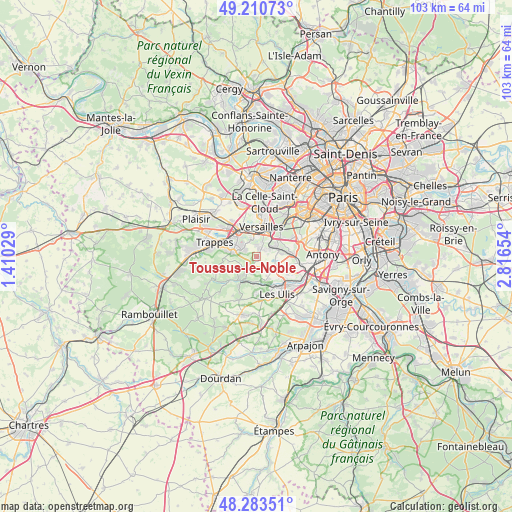
Toussus-le-Noble GPS coordinates[2]
48° 44' 57.336" North, 2° 6' 48.276" East
| Map corner | latitude | longitude |
|---|---|---|
| Upper-left | 49.21073°, | 1.41029° |
| Center: | 48.74926°, | 2.11341° |
| Lower-right: | 48.28351°, | 2.81654° |
| Map W x H: | 103.1×103.1 km | = 64.1×64.1mi |
| max Lat: | 51.07786° ⇑25.7% North |
| Toussus-le-Noble: | 48.74926° |
| min Lat: | ⇓74.3% South 41.3874° |
| min Long | Toussus-le-Nobl | max Long |
| -5.08615° | 2.11341° | 9.52242° |
| W 44.3%⇐ | ⇒55.7% E |
Elevation
Elevation of Toussus-le-Noble is 156 m = 512 ft, and this is 37.7 m = 124 ft below average elevation for this country.
| Max E: |
2333 m = 7654 ft | 43.4% |
| Avg. | 193.7 m = 635 ft | |
| Toussus-le-Noble | 156 m = 512 ft | |
Min E: |
-1 m = -3 ft | 56.6% |
See also: France elevation on elevation.city.
Geographical zone
Toussus-le-Noble is located in North temperate zone (between Tropic of Cancer and the Arctic Circle). Distance of this North polar circle is 1980.8 km =1230.8 mi to North.| Distance of | km | miles | from Toussus-le-Noble |
|---|---|---|---|
| North Pole | 4586.7 | 2850 | to North |
| Arctic Circle | 1980.8 | 1230.8 | to North |
| Tropic Cancer | 2814.5 | 1748.8 | to South |
| Equator | 5420.4 | 3368.1 | to South |


Nearby cities:
15 places around Toussus-le-Noble: (largest is in red/bold)
• Buc
3.1 km =1.9 mi,  16°
16°
• Châteaufort
2.2 km =1.4 mi,  228°
228°
• Guyancourt
3.9 km =2.4 mi,  312°
312°
• Jouy-en-Josas
4.3 km =2.7 mi,  75°
75°
• Les Loges-en-Josas
2.5 km =1.6 mi,  50°
50°
• Magny-les-Hameaux
3.9 km =2.4 mi,  260°
260°
• Montigny-le-Bretonneux
6.1 km =3.8 mi,  288°
288°
• Saclay
4.5 km =2.8 mi,  114°
114°
• Saint-Aubin
4.5 km =2.8 mi,  152°
152°
• Saint-Cyr-l’École
6.4 km =4 mi,  328°
328°
• Saint-Rémy-lès-Chevreuse
5.4 km =3.4 mi,  209°
209°
• Versailles
6.2 km =3.9 mi,  14°
14°
• Villiers-le-Bâcle
2.4 km =1.5 mi,  169°
169°
• Viroflay
6.7 km =4.2 mi,  31°
31°
• Voisins-le-Bretonneux
4.6 km =2.9 mi,  281°
281°
Sources, notices
• [Note1] Compared only with cities in France existing in our database
• [Src1] Map data: © OpenStreetMap contributors (CC-BY-SA)
• [Src2] Other city data from geonames.org with taken over terms of usage.
• [Src3] Geographical zone / Annual Mean Temperature by Robert A. Rohde @ Wikipedia
