Saint-Aubin geodata
Saint-Aubin (Île-de-France) is a populated place; located in France in Europe/Paris (GMT+2) time zone. With population of 745 people, there are 11223 cities with bigger population in this country. Compared to other cities in France, 73.5% of cities are located further ↓South; 55.2% of cities are located further →East and 57.6% of cities have lower elevation than Saint-Aubin. Note1
Administrative division(s):
- Level 1: Île-de-France
- Level 2: Département de l'Essonne
- Level 3: Arrondissement de Palaiseau
- Level 4: Saint-Aubin


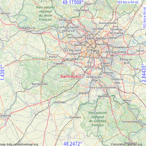
Saint-Aubin GPS coordinates[2]
48° 42' 47.808" North, 2° 8' 28.392" East
| Map corner | latitude | longitude |
|---|---|---|
| Upper-left | 49.17508°, | 1.4381° |
| Center: | 48.71328°, | 2.14122° |
| Lower-right: | 48.2472°, | 2.84435° |
| Map W x H: | 103.2×103.2 km | = 64.1×64.1mi |
| max Lat: | 51.07786° ⇑26.5% North |
| Saint-Aubin: | 48.71328° |
| min Lat: | ⇓73.5% South 41.3874° |
| min Long | Saint-Aubin | max Long |
| -5.08615° | 2.14122° | 9.52242° |
| W 44.8%⇐ | ⇒55.2% E |
Elevation
Elevation of Saint-Aubin is 160 m = 525 ft, and this is 33.7 m = 111 ft below average elevation for this country.
| Max E: |
2333 m = 7654 ft | 42.4% |
| Avg. | 193.7 m = 635 ft | |
| Saint-Aubin | 160 m = 525 ft | |
Min E: |
-1 m = -3 ft | 57.6% |
See also: France elevation on elevation.city.
Geographical zone
Saint-Aubin is located in North temperate zone (between Tropic of Cancer and the Arctic Circle). Distance of this North polar circle is 1984.8 km =1233.3 mi to North.| Distance of | km | miles | from Saint-Aubin |
|---|---|---|---|
| North Pole | 4590.7 | 2852.5 | to North |
| Arctic Circle | 1984.8 | 1233.3 | to North |
| Tropic Cancer | 2810.5 | 1746.4 | to South |
| Equator | 5416.4 | 3365.6 | to South |


Nearby cities:
15 places around Saint-Aubin: (largest is in red/bold)
• Bures-sur-Yvette
2.6 km =1.6 mi,  124°
124°
• Châteaufort
4.5 km =2.8 mi,  304°
304°
• Gif-sur-Yvette
3.4 km =2.1 mi,  189°
189°
• Gometz-la-Ville
4.7 km =2.9 mi, 191°
• Gometz-le-Châtel
3.9 km =2.4 mi,  183°
183°
• Jouy-en-Josas
5.5 km =3.4 mi,  22°
22°
• Les Loges-en-Josas
5.6 km =3.5 mi,  359°
359°
• Les Ulis
4.1 km =2.5 mi,  149°
149°
• Magny-les-Hameaux
6.7 km =4.2 mi, 299°
• Orsay
3.9 km =2.4 mi, 120°
• Saclay
3 km =1.9 mi,  43°
43°
• Saint-Rémy-lès-Chevreuse
4.8 km =3 mi,  261°
261°
• Toussus-le-Noble
4.5 km =2.8 mi,  332°
332°
• Vauhallan
5 km =3.1 mi,  63°
63°
• Villiers-le-Bâcle
2.3 km =1.4 mi,  315°
315°
Sources, notices
• [Note1] Compared only with cities in France existing in our database
• [Src1] Map data: © OpenStreetMap contributors (CC-BY-SA)
• [Src2] Other city data from geonames.org with taken over terms of usage.
• [Src3] Geographical zone / Annual Mean Temperature by Robert A. Rohde @ Wikipedia
