Saint-Pierre-du-Regard geodata
Saint-Pierre-du-Regard (Normandy) is a populated place; located in France in Europe/Paris (GMT+2) time zone. With population of 1,289 people, there are 7085 cities with bigger population in this country. Compared to other cities in France, 76.5% of cities are located further ↓South; 83.9% of cities are located further →East and 51.7% of cities have higher elevation than Saint-Pierre-du-Regard. Note1
Administrative division(s):
- Level 1: Normandy
- Level 2: Département de l'Orne
- Level 3: Argentan
- Level 4: Saint-Pierre-du-Regard
Current local time in Saint-Pierre-du-Regard:
08:07 PM, SaturdayDifference from your time zone: hours


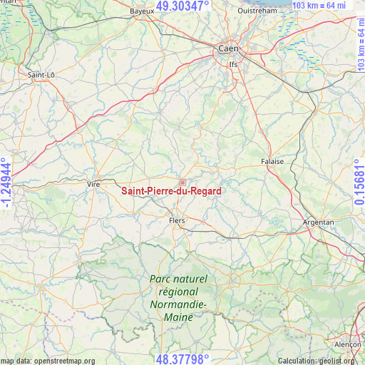
Saint-Pierre-du-Regard GPS coordinates[2]
48° 50' 34.296" North, 0° 32' 46.716" West
| Map corner | latitude | longitude |
|---|---|---|
| Upper-left | 49.30347°, | -1.24944° |
| Center: | 48.84286°, | -0.54631° |
| Lower-right: | 48.37798°, | 0.15681° |
| Map W x H: | 102.9×102.9 km | = 63.9×63.9mi |
| max Lat: | 51.07786° ⇑23.5% North |
| Saint-Pierre-du-Regard: | 48.84286° |
| min Lat: | ⇓76.5% South 41.3874° |
| min Long | Saint-Pierre-du | max Long |
| -5.08615° | -0.54631° | 9.52242° |
| W 16.1%⇐ | ⇒83.9% E |
Elevation
Elevation of Saint-Pierre-du-Regard is 126 m = 413 ft, and this is 67.7 m = 222 ft below average elevation for this country.
| Max E: |
2333 m = 7654 ft | 51.7% |
| Avg. | 193.7 m = 635 ft | |
| Saint-Pierre-du-Regard | 126 m = 413 ft | |
Min E: |
-1 m = -3 ft | 48.3% |
See also: France elevation on elevation.city.
Geographical zone
Saint-Pierre-du-Regard is located in North temperate zone (between Tropic of Cancer and the Arctic Circle). Distance of this North polar circle is 1970.4 km =1224.3 mi to North.| Distance of | km | miles | from Saint-Pierre-du-Regard |
|---|---|---|---|
| North Pole | 4576.2 | 2843.5 | to North |
| Arctic Circle | 1970.4 | 1224.3 | to North |
| Tropic Cancer | 2824.9 | 1755.3 | to South |
| Equator | 5430.8 | 3374.5 | to South |


Nearby cities:
15 places around Saint-Pierre-du-Regard: (largest is in red/bold)
• Athis-de-l'Orne
4.5 km =2.8 mi,  130°
130°
• Berjou
4.8 km =3 mi,  81°
81°
• Caligny
5.2 km =3.2 mi,  222°
222°
• Clécy
9.6 km =6 mi,  30°
30°
• Condé-sur-Noireau
0.8 km =0.5 mi,  327°
327°
• La Lande-Patry
9.8 km =6.1 mi,  203°
203°
• Montilly-sur-Noireau
3.6 km =2.2 mi,  209°
209°
• Montsecret
10.7 km =6.6 mi,  241°
241°
• Pont-d'Ouilly
11.2 km =7 mi,  70°
70°
• Saint-Denis-de-Méré
3.7 km =2.3 mi,  35°
35°
• Saint-Georges-des-Groseillers
8.3 km =5.2 mi,  190°
190°
• Saint-Germain-du-Crioult
4.5 km =2.8 mi,  289°
289°
• Saint-Rémy
11.3 km =7 mi,  16°
16°
• Sainte-Honorine-la-Chardonne
4.9 km =3 mi,  114°
114°
• Vassy
9.5 km =5.9 mi,  277°
277°
Sources, notices
• [Note1] Compared only with cities in France existing in our database
• [Src1] Map data: © OpenStreetMap contributors (CC-BY-SA)
• [Src2] Other city data from geonames.org with taken over terms of usage.
• [Src3] Geographical zone / Annual Mean Temperature by Robert A. Rohde @ Wikipedia
