Férel geodata
Férel (Brittany) is a populated place; located in France in Europe/Paris (GMT+2) time zone. With population of 2,189 people, there are 4387 cities with bigger population in this country. Compared to other cities in France, 50.9% of cities are located further ↓South; 95.9% of cities are located further →East and 86.2% of cities have higher elevation than Férel. Note1
Administrative division(s):
- Level 1: Brittany
- Level 2: Morbihan
- Level 3: Arrondissement de Vannes
- Level 4: Férel


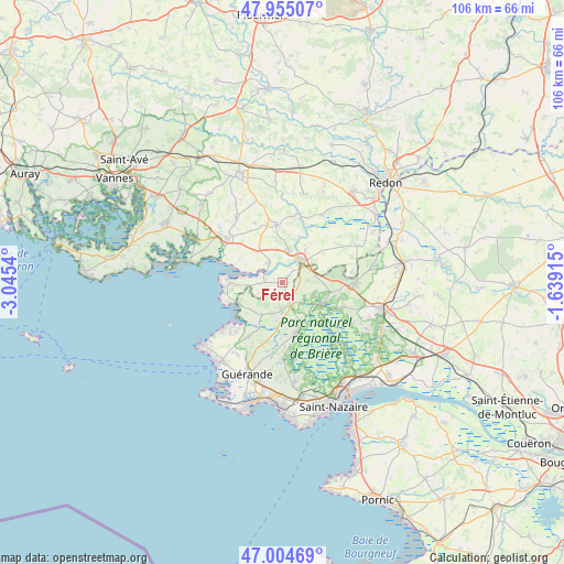
Férel GPS coordinates[2]
47° 28' 55.308" North, 2° 20' 32.172" West
| Map corner | latitude | longitude |
|---|---|---|
| Upper-left | 47.95507°, | -3.0454° |
| Center: | 47.48203°, | -2.34227° |
| Lower-right: | 47.00469°, | -1.63915° |
| Map W x H: | 105.7×105.7 km | = 65.7×65.7mi |
| max Lat: | 51.07786° ⇑49.1% North |
| Férel: | 47.48203° |
| min Lat: | ⇓50.9% South 41.3874° |
| min Long | Férel | max Long |
| -5.08615° | -2.34227° | 9.52242° |
| W 4.1%⇐ | ⇒95.9% E |
Elevation
Elevation of Férel is 39 m = 128 ft, and this is 154.7 m = 508 ft below average elevation for this country.
| Max E: |
2333 m = 7654 ft | 86.2% |
| Avg. | 193.7 m = 635 ft | |
| Férel | 39 m = 128 ft | |
Min E: |
-1 m = -3 ft | 13.8% |
See also: France elevation on elevation.city.
Geographical zone
Férel is located in North temperate zone (between Tropic of Cancer and the Arctic Circle). Distance of this North polar circle is 2121.7 km =1318.4 mi to North.| Distance of | km | miles | from Férel |
|---|---|---|---|
| North Pole | 4727.6 | 2937.6 | to North |
| Arctic Circle | 2121.7 | 1318.4 | to North |
| Tropic Cancer | 2673.6 | 1661.3 | to South |
| Equator | 5279.5 | 3280.5 | to South |


Nearby cities:
15 places around Férel: (largest is in red/bold)
• Arzal
4.6 km =2.9 mi,  326°
326°
• Assérac
6.9 km =4.3 mi,  210°
210°
• Billiers
12.2 km =7.6 mi,  296°
296°
• Camoël
4 km =2.5 mi,  268°
268°
• Herbignac
4.2 km =2.6 mi,  154°
154°
• La Chapelle-des-Marais
8.7 km =5.4 mi,  115°
115°
• La Roche-Bernard
5.1 km =3.2 mi,  36°
36°
• Le Guerno
12.3 km =7.6 mi,  336°
336°
• Marzan
6.7 km =4.2 mi,  11°
11°
• Nivillac
7.3 km =4.5 mi, 37°
• Péaule
10.9 km =6.8 mi,  354°
354°
• Pénestin
9.8 km =6.1 mi, 270°
• Saint-Lyphard
9.7 km =6 mi,  163°
163°
• Saint-Molf
11.8 km =7.3 mi, 211°
• Sainte-Reine-de-Bretagne
12.1 km =7.5 mi,  111°
111°
Sources, notices
• [Note1] Compared only with cities in France existing in our database
• [Src1] Map data: © OpenStreetMap contributors (CC-BY-SA)
• [Src2] Other city data from geonames.org with taken over terms of usage.
• [Src3] Geographical zone / Annual Mean Temperature by Robert A. Rohde @ Wikipedia
