Saint-Mesmin geodata
Saint-Mesmin (Grand Est) is a populated place; located in France in Europe/Paris (GMT+2) time zone. With population of 848 people, there are 10102 cities with bigger population in this country. Compared to other cities in France, 67.1% of cities are located further ↓South; 67.2% of cities are located further ←West and 64% of cities have higher elevation than Saint-Mesmin. Note1
Administrative division(s):
- Level 1: Grand Est
- Level 2: Département de l'Aube
- Level 3: Arrondissement de Nogent-sur-Seine
- Level 4: Saint-Mesmin


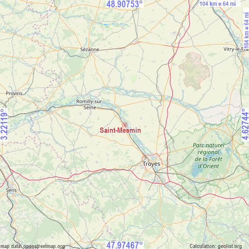
Saint-Mesmin GPS coordinates[2]
48° 26' 35.664" North, 3° 55' 27.552" East
| Map corner | latitude | longitude |
|---|---|---|
| Upper-left | 48.90753°, | 3.22119° |
| Center: | 48.44324°, | 3.92432° |
| Lower-right: | 47.97467°, | 4.62744° |
| Map W x H: | 103.7×103.7 km | = 64.4×64.4mi |
| max Lat: | 51.07786° ⇑32.9% North |
| Saint-Mesmin: | 48.44324° |
| min Lat: | ⇓67.1% South 41.3874° |
| min Long | Saint-Mesmin | max Long |
| -5.08615° | 3.92432° | 9.52242° |
| W 67.2%⇐ | ⇒32.8% E |
Elevation
Elevation of Saint-Mesmin is 92 m = 302 ft, and this is 101.7 m = 334 ft below average elevation for this country.
| Max E: |
2333 m = 7654 ft | 64% |
| Avg. | 193.7 m = 635 ft | |
| Saint-Mesmin | 92 m = 302 ft | |
Min E: |
-1 m = -3 ft | 36% |
See also: France elevation on elevation.city.
Geographical zone
Saint-Mesmin is located in North temperate zone (between Tropic of Cancer and the Arctic Circle). Distance of this North polar circle is 2014.8 km =1251.9 mi to North.| Distance of | km | miles | from Saint-Mesmin |
|---|---|---|---|
| North Pole | 4620.7 | 2871.2 | to North |
| Arctic Circle | 2014.8 | 1251.9 | to North |
| Tropic Cancer | 2780.5 | 1727.7 | to South |
| Equator | 5386.4 | 3347 | to South |


Nearby cities:
15 places around Saint-Mesmin: (largest is in red/bold)
• Barberey-Saint-Sulpice
14.1 km =8.8 mi,  145°
145°
• Châtres
8.5 km =5.3 mi,  318°
318°
• Clesles
12.1 km =7.5 mi,  326°
326°
• Fontaine-les-Grès
3.5 km =2.2 mi,  211°
211°
• Maizières-la-Grande-Paroisse
12.6 km =7.8 mi,  306°
306°
• Marigny-le-Châtel
14.6 km =9.1 mi,  252°
252°
• Mergey
9 km =5.6 mi,  136°
136°
• Méry-sur-Seine
7.7 km =4.8 mi,  341°
341°
• Origny-le-Sec
11.4 km =7.1 mi,  282°
282°
• Ossey-les-Trois-Maisons
13.5 km =8.4 mi,  266°
266°
• Payns
7.8 km =4.8 mi, 149°
• Plancy-l'Abbaye
14.1 km =8.8 mi,  12°
12°
• Saint-Lyé
10.3 km =6.4 mi, 147°
• Sainte-Maure
14.6 km =9.1 mi, 136°
• Savières
4.2 km =2.6 mi, 153°
Sources, notices
• [Note1] Compared only with cities in France existing in our database
• [Src1] Map data: © OpenStreetMap contributors (CC-BY-SA)
• [Src2] Other city data from geonames.org with taken over terms of usage.
• [Src3] Geographical zone / Annual Mean Temperature by Robert A. Rohde @ Wikipedia
