Bourbon-l’Archambault geodata
Bourbon-l’Archambault (Auvergne-Rhône-Alpes) is a populated place; located in France in Europe/Paris (GMT+2) time zone. With population of 2,559 people, there are 3809 cities with bigger population in this country. Compared to other cities in France, 59.4% of cities are located further ↑North; 58.6% of cities are located further ←West and 77.3% of cities have lower elevation than Bourbon-l’Archambault. Note1
Administrative division(s):
- Level 1: Auvergne-Rhône-Alpes
- Level 2: Département de l'Allier
- Level 3: Arrondissement de Moulins
- Level 4: Bourbon-l'Archambault
Current local time in Bourbon-l’Archambault:
05:18 AM, SaturdayDifference from your time zone: hours


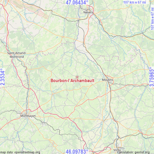
Bourbon-l’Archambault GPS coordinates[2]
46° 34' 59.664" North, 3° 3' 23.472" East
| Map corner | latitude | longitude |
|---|---|---|
| Upper-left | 47.06434°, | 2.3534° |
| Center: | 46.58324°, | 3.05652° |
| Lower-right: | 46.09783°, | 3.75965° |
| Map W x H: | 107.5×107.5 km | = 66.8×66.8mi |
| max Lat: | 51.07786° ⇑59.4% North |
| Bourbon-l’Archambault: | 46.58324° |
| min Lat: | ⇓40.6% South 41.3874° |
| min Long | Bourbon-l’Arc | max Long |
| -5.08615° | 3.05652° | 9.52242° |
| W 58.6%⇐ | ⇒41.4% E |
Elevation
Elevation of Bourbon-l’Archambault is 266 m = 873 ft, and this is 72.3 m = 237 ft above average elevation for this country.
| Max E: |
2333 m = 7654 ft | 22.7% |
| Bourbon-l’Archambault | 266 m 873 ft | |
| Avg. | 193.7 m = 635 ft | |
Min E: |
-1 m = -3 ft | 77.3% |
See also: France elevation on elevation.city.
Geographical zone
Bourbon-l’Archambault is located in North temperate zone (between Tropic of Cancer and the Arctic Circle). Distance of this North polar circle is 2221.6 km =1380.4 mi to North.| Distance of | km | miles | from Bourbon-l’Archambault |
|---|---|---|---|
| North Pole | 4827.5 | 2999.7 | to North |
| Arctic Circle | 2221.6 | 1380.4 | to North |
| Tropic Cancer | 2573.7 | 1599.2 | to South |
| Equator | 5179.6 | 3218.5 | to South |


Nearby cities:
15 places around Bourbon-l’Archambault: (largest is in red/bold)
• Buxières-les-Mines
14.8 km =9.2 mi,  209°
209°
• Coulandon
15.7 km =9.8 mi,  103°
103°
• Couleuvre
15.1 km =9.4 mi,  311°
311°
• Cressanges
17.2 km =10.7 mi,  152°
152°
• Cérilly
18.4 km =11.4 mi,  282°
282°
• Lurcy-Lévis
18.6 km =11.6 mi,  331°
331°
• Montilly
15.3 km =9.5 mi,  77°
77°
• Neuvy
18 km =11.2 mi, 97°
• Noyant-d’Allier
12.6 km =7.8 mi,  156°
156°
• Saint-Hilaire
10.3 km =6.4 mi,  195°
195°
• Saint-Menoux
8 km =5 mi,  89°
89°
• Souvigny
11.7 km =7.3 mi,  117°
117°
• Tronget
17.9 km =11.1 mi,  177°
177°
• Villeneuve-sur-Allier
17 km =10.6 mi,  59°
59°
• Ygrande
9.3 km =5.8 mi,  248°
248°
Sources, notices
• [Note1] Compared only with cities in France existing in our database
• [Src1] Map data: © OpenStreetMap contributors (CC-BY-SA)
• [Src2] Other city data from geonames.org with taken over terms of usage.
• [Src3] Geographical zone / Annual Mean Temperature by Robert A. Rohde @ Wikipedia
