Saint-Maurice-sur-Aveyron geodata
Saint-Maurice-sur-Aveyron (Centre) is a populated place; located in France in Europe/Paris (GMT+2) time zone. With population of 837 people, there are 10216 cities with bigger population in this country. Compared to other cities in France, 56.6% of cities are located further ↓South; 56.7% of cities are located further ←West and 59.8% of cities have lower elevation than Saint-Maurice-sur-Aveyron. Note1
Administrative division(s):
- Level 1: Centre
- Level 2: Loiret
- Level 3: Arrondissement de Montargis
- Level 4: Saint-Maurice-sur-Aveyron
Current local time in Saint-Maurice-sur-Aveyron:
04:19 AM, WednesdayDifference from your time zone: hours


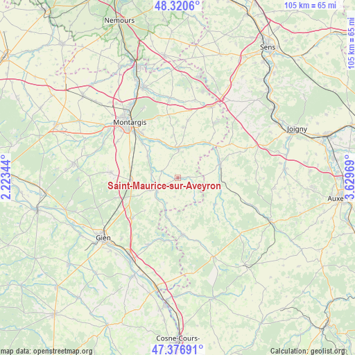
Saint-Maurice-sur-Aveyron GPS coordinates[2]
47° 51' 3.24" North, 2° 55' 35.652" East
| Map corner | latitude | longitude |
|---|---|---|
| Upper-left | 48.3206°, | 2.22344° |
| Center: | 47.8509°, | 2.92657° |
| Lower-right: | 47.37691°, | 3.62969° |
| Map W x H: | 104.9×104.9 km | = 65.2×65.2mi |
| max Lat: | 51.07786° ⇑43.4% North |
| Saint-Maurice-sur-Aveyron: | 47.8509° |
| min Lat: | ⇓56.6% South 41.3874° |
| min Long | Saint-Maurice-s | max Long |
| -5.08615° | 2.92657° | 9.52242° |
| W 56.7%⇐ | ⇒43.3% E |
Elevation
Elevation of Saint-Maurice-sur-Aveyron is 169 m = 554 ft, and this is 24.7 m = 81 ft below average elevation for this country.
| Max E: |
2333 m = 7654 ft | 40.2% |
| Avg. | 193.7 m = 635 ft | |
| Saint-Maurice-sur-Aveyron | 169 m = 554 ft | |
Min E: |
-1 m = -3 ft | 59.8% |
See also: France elevation on elevation.city.
Geographical zone
Saint-Maurice-sur-Aveyron is located in North temperate zone (between Tropic of Cancer and the Arctic Circle). Distance of this North polar circle is 2080.7 km =1292.9 mi to North.| Distance of | km | miles | from Saint-Maurice-sur-Aveyron |
|---|---|---|---|
| North Pole | 4686.5 | 2912.1 | to North |
| Arctic Circle | 2080.7 | 1292.9 | to North |
| Tropic Cancer | 2714.6 | 1686.8 | to South |
| Equator | 5320.5 | 3306 | to South |


Nearby cities:
15 places around Saint-Maurice-sur-Aveyron: (largest is in red/bold)
• Champignelles
13.6 km =8.5 mi,  125°
125°
• Charny
13.2 km =8.2 mi,  72°
72°
• Château-Renard
9.2 km =5.7 mi,  3°
3°
• Châtillon-Coligny
6.8 km =4.2 mi,  242°
242°
• Dammarie-sur-Loing
8.2 km =5.1 mi,  204°
204°
• Douchy
13.9 km =8.6 mi,  42°
42°
• Gy-les-Nonains
12.1 km =7.5 mi,  332°
332°
• Melleroy
5.3 km =3.3 mi,  22°
22°
• Montbouy
8 km =5 mi,  277°
277°
• Montcresson
10.7 km =6.6 mi,  304°
304°
• Nogent-sur-Vernisson
13.7 km =8.5 mi,  267°
267°
• Rogny-les-Sept-Écluses
11.7 km =7.3 mi, 196°
• Saint-Germain-des-Prés
12.8 km =8 mi, 333°
• Sainte-Geneviève-des-Bois
9 km =5.6 mi,  245°
245°
• Triguères
10.8 km =6.7 mi, 24°
Sources, notices
• [Note1] Compared only with cities in France existing in our database
• [Src1] Map data: © OpenStreetMap contributors (CC-BY-SA)
• [Src2] Other city data from geonames.org with taken over terms of usage.
• [Src3] Geographical zone / Annual Mean Temperature by Robert A. Rohde @ Wikipedia
