Douchy geodata
Douchy (Centre) is a populated place; located in France in Europe/Paris (GMT+2) time zone. With population of 1,048 people, there are 8479 cities with bigger population in this country. Compared to other cities in France, 58.3% of cities are located further ↓South; 58.6% of cities are located further ←West and 51.4% of cities have higher elevation than Douchy. Note1
Administrative division(s):
- Level 1: Centre
- Level 2: Loiret
- Level 3: Arrondissement de Montargis
- Level 4: Douchy-Montcorbon


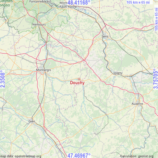
Douchy GPS coordinates[2]
47° 56' 34.152" North, 3° 3' 14.112" East
| Map corner | latitude | longitude |
|---|---|---|
| Upper-left | 48.41168°, | 2.3508° |
| Center: | 47.94282°, | 3.05392° |
| Lower-right: | 47.46967°, | 3.75705° |
| Map W x H: | 104.7×104.7 km | = 65.1×65.1mi |
| max Lat: | 51.07786° ⇑41.7% North |
| Douchy: | 47.94282° |
| min Lat: | ⇓58.3% South 41.3874° |
| min Long | Douchy | max Long |
| -5.08615° | 3.05392° | 9.52242° |
| W 58.6%⇐ | ⇒41.4% E |
Elevation
Elevation of Douchy is 127 m = 417 ft, and this is 66.7 m = 219 ft below average elevation for this country.
| Max E: |
2333 m = 7654 ft | 51.4% |
| Avg. | 193.7 m = 635 ft | |
| Douchy | 127 m = 417 ft | |
Min E: |
-1 m = -3 ft | 48.6% |
See also: France elevation on elevation.city.
Geographical zone
Douchy is located in North temperate zone (between Tropic of Cancer and the Arctic Circle). Distance of this North polar circle is 2070.4 km =1286.5 mi to North.| Distance of | km | miles | from Douchy |
|---|---|---|---|
| North Pole | 4676.3 | 2905.7 | to North |
| Arctic Circle | 2070.4 | 1286.5 | to North |
| Tropic Cancer | 2724.8 | 1693.1 | to South |
| Equator | 5330.7 | 3312.3 | to South |


Nearby cities:
15 places around Douchy: (largest is in red/bold)
• Charny
7 km =4.3 mi,  153°
153°
• Chuelles
9.3 km =5.8 mi,  315°
315°
• Château-Renard
9 km =5.6 mi,  263°
263°
• Courtenay
10.7 km =6.6 mi,  1°
1°
• Gy-les-Nonains
15.2 km =9.4 mi,  271°
271°
• La Ferté-Loupière
14.3 km =8.9 mi,  110°
110°
• La Selle-en-Hermoy
14.1 km =8.8 mi,  302°
302°
• La Selle-sur-le-Bied
17.8 km =11.1 mi, 319°
• Melleroy
9.2 km =5.7 mi,  234°
234°
• Piffonds
14.3 km =8.9 mi,  29°
29°
• Saint-Germain-des-Prés
15.4 km =9.6 mi, 274°
• Saint-Hilaire-les-Andrésis
12.6 km =7.8 mi,  346°
346°
• Saint-Maurice-sur-Aveyron
13.9 km =8.6 mi,  222°
222°
• Triguères
5.1 km =3.2 mi, 266°
• Villefranche
6 km =3.7 mi,  100°
100°
Sources, notices
• [Note1] Compared only with cities in France existing in our database
• [Src1] Map data: © OpenStreetMap contributors (CC-BY-SA)
• [Src2] Other city data from geonames.org with taken over terms of usage.
• [Src3] Geographical zone / Annual Mean Temperature by Robert A. Rohde @ Wikipedia
