Saint-Marc-Jaumegarde geodata
Saint-Marc-Jaumegarde (Provence-Alpes-Côte d'Azur) is a populated place; located in France in Europe/Paris (GMT+2) time zone. With population of 1,132 people, there are 7932 cities with bigger population in this country. Compared to other cities in France, 92.5% of cities are located further ↑North; 83.1% of cities are located further ←West and 87.4% of cities have lower elevation than Saint-Marc-Jaumegarde. Note1
Administrative division(s):
- Level 1: Provence-Alpes-Côte d'Azur
- Level 2: Département des Bouches-du-Rhône
- Level 3: Aix-en-Provence
- Level 4: Saint-Marc-Jaumegarde
Current local time in Saint-Marc-Jaumegarde:
04:42 AM, WednesdayDifference from your time zone: hours


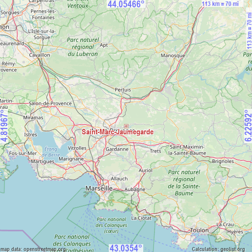
Saint-Marc-Jaumegarde GPS coordinates[2]
43° 32' 49.848" North, 5° 31' 22.08" East
| Map corner | latitude | longitude |
|---|---|---|
| Upper-left | 44.05466°, | 4.81967° |
| Center: | 43.54718°, | 5.5228° |
| Lower-right: | 43.0354°, | 6.22592° |
| Map W x H: | 113.3×113.3 km | = 70.4×70.4mi |
| max Lat: | 51.07786° ⇑92.5% North |
| Saint-Marc-Jaumegarde: | 43.54718° |
| min Lat: | ⇓7.5% South 41.3874° |
| min Long | Saint-Marc-Jaum | max Long |
| -5.08615° | 5.5228° | 9.52242° |
| W 83.1%⇐ | ⇒16.9% E |
Elevation
Elevation of Saint-Marc-Jaumegarde is 380 m = 1247 ft, and this is 186.3 m = 611 ft above average elevation for this country.
| Max E: |
2333 m = 7654 ft | 12.6% |
| Saint-Marc-Jaumegarde | 380 m 1247 ft | |
| Avg. | 193.7 m = 635 ft | |
Min E: |
-1 m = -3 ft | 87.4% |
See also: France elevation on elevation.city.
Geographical zone
Saint-Marc-Jaumegarde is located in North temperate zone (between Tropic of Cancer and the Arctic Circle). Distance of this Northern Tropic circle is 2236.1 km =1389.4 mi to South.| Distance of | km | miles | from Saint-Marc-Jaumegarde |
|---|---|---|---|
| North Pole | 5165.1 | 3209.4 | to North |
| Arctic Circle | 2559.2 | 1590.2 | to North |
| Tropic Cancer | 2236.1 | 1389.4 | to South |
| Equator | 4842 | 3008.7 | to South |


Nearby cities:
15 places around Saint-Marc-Jaumegarde: (largest is in red/bold)
• Aix-en-Provence
6.3 km =3.9 mi,  250°
250°
• Beaurecueil
4.3 km =2.7 mi,  154°
154°
• Châteauneuf-le-Rouge
7.4 km =4.6 mi, 149°
• Fuveau
10.6 km =6.6 mi,  162°
162°
• Gardanne
11.1 km =6.9 mi,  202°
202°
• Gréasque
12.8 km =8 mi,  172°
172°
• Jouques
13.6 km =8.5 mi,  42°
42°
• Le Tholonet
3 km =1.9 mi, 198°
• Meyrargues
10 km =6.2 mi,  1°
1°
• Meyreuil
7 km =4.3 mi, 198°
• Peyrolles-en-Provence
12 km =7.5 mi,  24°
24°
• Puyloubier
12.6 km =7.8 mi,  101°
101°
• Rousset
10.6 km =6.6 mi,  132°
132°
• Vauvenargues
6.2 km =3.9 mi,  81°
81°
• Venelles
6.7 km =4.2 mi,  328°
328°
Sources, notices
• [Note1] Compared only with cities in France existing in our database
• [Src1] Map data: © OpenStreetMap contributors (CC-BY-SA)
• [Src2] Other city data from geonames.org with taken over terms of usage.
• [Src3] Geographical zone / Annual Mean Temperature by Robert A. Rohde @ Wikipedia
