Vauvenargues geodata
Vauvenargues (Provence-Alpes-Côte d'Azur) is a populated place; located in France in Europe/Paris (GMT+2) time zone. With population of 759 people, there are 11065 cities with bigger population in this country. Compared to other cities in France, 92.4% of cities are located further ↑North; 83.7% of cities are located further ←West and 90.6% of cities have lower elevation than Vauvenargues. Note1
Administrative division(s):
- Level 1: Provence-Alpes-Côte d'Azur
- Level 2: Département des Bouches-du-Rhône
- Level 3: Aix-en-Provence
- Level 4: Vauvenargues


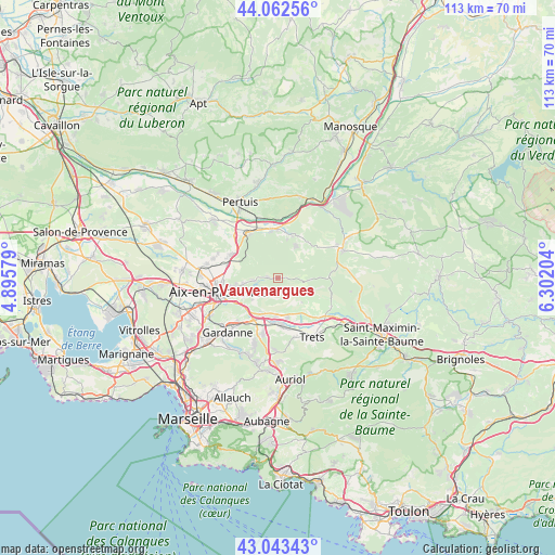
Vauvenargues GPS coordinates[2]
43° 33' 18.54" North, 5° 35' 56.112" East
| Map corner | latitude | longitude |
|---|---|---|
| Upper-left | 44.06256°, | 4.89579° |
| Center: | 43.55515°, | 5.59892° |
| Lower-right: | 43.04343°, | 6.30204° |
| Map W x H: | 113.3×113.3 km | = 70.4×70.4mi |
| max Lat: | 51.07786° ⇑92.4% North |
| Vauvenargues: | 43.55515° |
| min Lat: | ⇓7.6% South 41.3874° |
| min Long | Vauvenargues | max Long |
| -5.08615° | 5.59892° | 9.52242° |
| W 83.7%⇐ | ⇒16.3% E |
Elevation
Elevation of Vauvenargues is 439 m = 1440 ft, and this is 245.3 m = 805 ft above average elevation for this country.
| Max E: |
2333 m = 7654 ft | 9.4% |
| Vauvenargues | 439 m 1440 ft | |
| Avg. | 193.7 m = 635 ft | |
Min E: |
-1 m = -3 ft | 90.6% |
See also: France elevation on elevation.city.
Geographical zone
Vauvenargues is located in North temperate zone (between Tropic of Cancer and the Arctic Circle). Distance of this Northern Tropic circle is 2237 km =1390 mi to South.| Distance of | km | miles | from Vauvenargues |
|---|---|---|---|
| North Pole | 5164.2 | 3208.9 | to North |
| Arctic Circle | 2558.3 | 1589.7 | to North |
| Tropic Cancer | 2237 | 1390 | to South |
| Equator | 4842.9 | 3009.2 | to South |


Nearby cities:
15 places around Vauvenargues: (largest is in red/bold)
• Aix-en-Provence
12.4 km =7.7 mi,  256°
256°
• Beaurecueil
6.4 km =4 mi,  221°
221°
• Châteauneuf-le-Rouge
7.7 km =4.8 mi,  198°
198°
• Fuveau
11.5 km =7.1 mi, 195°
• Jouques
9.6 km =6 mi,  18°
18°
• Le Tholonet
8 km =5 mi,  242°
242°
• Meyrargues
10.8 km =6.7 mi,  327°
327°
• Meyreuil
11.2 km =7 mi,  228°
228°
• Peynier
12.4 km =7.7 mi,  163°
163°
• Peyrolles-en-Provence
10.1 km =6.3 mi,  353°
353°
• Pourrières
12.2 km =7.6 mi,  116°
116°
• Puyloubier
7.1 km =4.4 mi, 118°
• Rousset
8.2 km =5.1 mi,  168°
168°
• Saint-Marc-Jaumegarde
6.2 km =3.9 mi, 261°
• Venelles
10.7 km =6.6 mi,  296°
296°
Sources, notices
• [Note1] Compared only with cities in France existing in our database
• [Src1] Map data: © OpenStreetMap contributors (CC-BY-SA)
• [Src2] Other city data from geonames.org with taken over terms of usage.
• [Src3] Geographical zone / Annual Mean Temperature by Robert A. Rohde @ Wikipedia
