Aix-en-Provence geodata
Aix-en-Provence (Provence-Alpes-Côte d'Azur) is a seat of a third-order administrative division; located in France in Europe/Paris (GMT+2) time zone. With population of 146,821 people, there are 20 cities with bigger population in this country. Compared to other cities in France, 92.7% of cities are located further ↑North; 82.5% of cities are located further ←West and 67.2% of cities have lower elevation than Aix-en-Provence. Note1
Administrative division(s):
- Level 1: Provence-Alpes-Côte d'Azur
- Level 2: Département des Bouches-du-Rhône
- Level 3: Aix-en-Provence
- Level 4: Aix-en-Provence


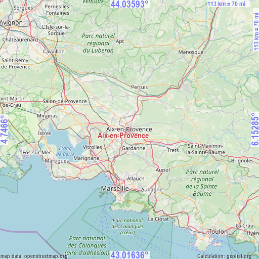
Aix-en-Provence GPS coordinates[2]
43° 31' 41.88" North, 5° 26' 59.028" East
| Map corner | latitude | longitude |
|---|---|---|
| Upper-left | 44.03593°, | 4.7466° |
| Center: | 43.5283°, | 5.44973° |
| Lower-right: | 43.01636°, | 6.15285° |
| Map W x H: | 113.4×113.4 km | = 70.5×70.5mi |
| max Lat: | 51.07786° ⇑92.7% North |
| Aix-en-Provence: | 43.5283° |
| min Lat: | ⇓7.3% South 41.3874° |
| min Long | Aix-en-Provence | max Long |
| -5.08615° | 5.44973° | 9.52242° |
| W 82.5%⇐ | ⇒17.5% E |
Elevation
Elevation of Aix-en-Provence is 205 m = 673 ft, and this is 11.3 m = 37 ft above average elevation for this country.
| Max E: |
2333 m = 7654 ft | 32.8% |
| Aix-en-Provence | 205 m 673 ft | |
| Avg. | 193.7 m = 635 ft | |
Min E: |
-1 m = -3 ft | 67.2% |
See also: Aix-en-Provence elevation on elevation.city.
Geographical zone
Aix-en-Provence is located in North temperate zone (between Tropic of Cancer and the Arctic Circle). Distance of this Northern Tropic circle is 2234 km =1388.1 mi to South.| Distance of | km | miles | from Aix-en-Provence |
|---|---|---|---|
| North Pole | 5167.2 | 3210.7 | to North |
| Arctic Circle | 2561.3 | 1591.5 | to North |
| Tropic Cancer | 2234 | 1388.1 | to South |
| Equator | 4839.9 | 3007.4 | to South |


Nearby cities:
15 places around Aix-en-Provence: (largest is in red/bold)
• Beaurecueil
7.9 km =4.9 mi,  103°
103°
• Bouc-Bel-Air
9 km =5.6 mi,  199°
199°
• Cabriès
11.2 km =7 mi,  210°
210°
• Châteauneuf-le-Rouge
10.6 km =6.6 mi,  114°
114°
• Fuveau
12.1 km =7.5 mi,  131°
131°
• Gardanne
8.3 km =5.2 mi,  169°
169°
• Gréasque
13.1 km =8.1 mi,  144°
144°
• Le Tholonet
5 km =3.1 mi, 98°
• Meyreuil
5.8 km =3.6 mi, 140°
• Saint-Marc-Jaumegarde
6.3 km =3.9 mi,  70°
70°
• Simiane-Collongue
10.9 km =6.8 mi,  186°
186°
• Vauvenargues
12.4 km =7.7 mi,  76°
76°
• Venelles
8.2 km =5.1 mi,  17°
17°
• Ventabren
12.5 km =7.8 mi,  275°
275°
• Éguilles
8.8 km =5.5 mi,  300°
300°
Sources, notices
• [Note1] Compared only with cities in France existing in our database
• [Src1] Map data: © OpenStreetMap contributors (CC-BY-SA)
• [Src2] Other city data from geonames.org with taken over terms of usage.
• [Src3] Geographical zone / Annual Mean Temperature by Robert A. Rohde @ Wikipedia
