Châteauneuf-le-Rouge geodata
Châteauneuf-le-Rouge (Provence-Alpes-Côte d'Azur) is a populated place; located in France in Europe/Paris (GMT+2) time zone. With population of 2,114 people, there are 4554 cities with bigger population in this country. Compared to other cities in France, 93.2% of cities are located further ↑North; 83.5% of cities are located further ←West and 72% of cities have lower elevation than Châteauneuf-le-Rouge. Note1
Administrative division(s):
- Level 1: Provence-Alpes-Côte d'Azur
- Level 2: Département des Bouches-du-Rhône
- Level 3: Aix-en-Provence
- Level 4: Châteauneuf-le-Rouge
Current local time in Châteauneuf-le-Rouge:
11:06 AM, WednesdayDifference from your time zone: hours


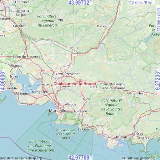
Châteauneuf-le-Rouge GPS coordinates[2]
43° 29' 21.696" North, 5° 34' 9.156" East
| Map corner | latitude | longitude |
|---|---|---|
| Upper-left | 43.99732°, | 4.86608° |
| Center: | 43.48936°, | 5.56921° |
| Lower-right: | 42.97709°, | 6.27233° |
| Map W x H: | 113.4×113.4 km | = 70.5×70.5mi |
| max Lat: | 51.07786° ⇑93.2% North |
| Châteauneuf-le-Rouge: | 43.48936° |
| min Lat: | ⇓6.8% South 41.3874° |
| min Long | Châteauneuf-le | max Long |
| -5.08615° | 5.56921° | 9.52242° |
| W 83.5%⇐ | ⇒16.5% E |
Elevation
Elevation of Châteauneuf-le-Rouge is 230 m = 755 ft, and this is 36.3 m = 119 ft above average elevation for this country.
| Max E: |
2333 m = 7654 ft | 28% |
| Châteauneuf-le-Rouge | 230 m 755 ft | |
| Avg. | 193.7 m = 635 ft | |
Min E: |
-1 m = -3 ft | 72% |
See also: France elevation on elevation.city.
Geographical zone
Châteauneuf-le-Rouge is located in North temperate zone (between Tropic of Cancer and the Arctic Circle). Distance of this Northern Tropic circle is 2229.6 km =1385.4 mi to South.| Distance of | km | miles | from Châteauneuf-le-Rouge |
|---|---|---|---|
| North Pole | 5171.5 | 3213.4 | to North |
| Arctic Circle | 2565.6 | 1594.2 | to North |
| Tropic Cancer | 2229.6 | 1385.4 | to South |
| Equator | 4835.6 | 3004.7 | to South |


Nearby cities:
15 places around Châteauneuf-le-Rouge: (largest is in red/bold)
• Beaurecueil
3.1 km =1.9 mi,  322°
322°
• Belcodène
7.2 km =4.5 mi,  167°
167°
• Fuveau
3.8 km =2.4 mi,  189°
189°
• Gardanne
8.9 km =5.5 mi,  244°
244°
• Gréasque
6.6 km =4.1 mi,  197°
197°
• Le Tholonet
5.9 km =3.7 mi,  307°
307°
• Meyreuil
5.9 km =3.7 mi,  268°
268°
• Mimet
9.8 km =6.1 mi,  211°
211°
• Peynier
7.4 km =4.6 mi,  128°
128°
• Puyloubier
9.5 km =5.9 mi,  65°
65°
• Rousset
4.1 km =2.5 mi,  99°
99°
• Saint-Marc-Jaumegarde
7.4 km =4.6 mi,  329°
329°
• Saint-Savournin
9.6 km =6 mi, 200°
• Trets
10.3 km =6.4 mi,  116°
116°
• Vauvenargues
7.7 km =4.8 mi,  18°
18°
Sources, notices
• [Note1] Compared only with cities in France existing in our database
• [Src1] Map data: © OpenStreetMap contributors (CC-BY-SA)
• [Src2] Other city data from geonames.org with taken over terms of usage.
• [Src3] Geographical zone / Annual Mean Temperature by Robert A. Rohde @ Wikipedia
