Puyloubier geodata
Puyloubier (Provence-Alpes-Côte d'Azur) is a populated place; located in France in Europe/Paris (GMT+2) time zone. With population of 1,661 people, there are 5634 cities with bigger population in this country. Compared to other cities in France, 92.8% of cities are located further ↑North; 84.2% of cities are located further ←West and 85.3% of cities have lower elevation than Puyloubier. Note1
Administrative division(s):
- Level 1: Provence-Alpes-Côte d'Azur
- Level 2: Département des Bouches-du-Rhône
- Level 3: Aix-en-Provence
- Level 4: Puyloubier


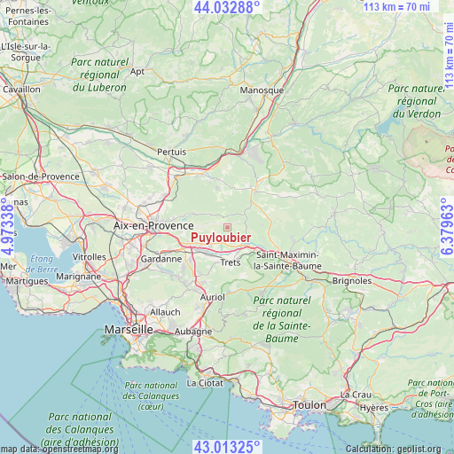
Puyloubier GPS coordinates[2]
43° 31' 30.792" North, 5° 40' 35.4" East
| Map corner | latitude | longitude |
|---|---|---|
| Upper-left | 44.03288°, | 4.97338° |
| Center: | 43.52522°, | 5.6765° |
| Lower-right: | 43.01325°, | 6.37963° |
| Map W x H: | 113.4×113.4 km | = 70.5×70.5mi |
| max Lat: | 51.07786° ⇑92.8% North |
| Puyloubier: | 43.52522° |
| min Lat: | ⇓7.2% South 41.3874° |
| min Long | Puyloubier | max Long |
| -5.08615° | 5.6765° | 9.52242° |
| W 84.2%⇐ | ⇒15.8% E |
Elevation
Elevation of Puyloubier is 350 m = 1148 ft, and this is 156.3 m = 513 ft above average elevation for this country.
| Max E: |
2333 m = 7654 ft | 14.7% |
| Puyloubier | 350 m 1148 ft | |
| Avg. | 193.7 m = 635 ft | |
Min E: |
-1 m = -3 ft | 85.3% |
See also: France elevation on elevation.city.
Geographical zone
Puyloubier is located in North temperate zone (between Tropic of Cancer and the Arctic Circle). Distance of this Northern Tropic circle is 2233.6 km =1387.9 mi to South.| Distance of | km | miles | from Puyloubier |
|---|---|---|---|
| North Pole | 5167.5 | 3210.9 | to North |
| Arctic Circle | 2561.6 | 1591.7 | to North |
| Tropic Cancer | 2233.6 | 1387.9 | to South |
| Equator | 4839.6 | 3007.2 | to South |


Nearby cities:
15 places around Puyloubier: (largest is in red/bold)
• Beaurecueil
10.7 km =6.6 mi,  262°
262°
• Belcodène
13.1 km =8.1 mi,  212°
212°
• Châteauneuf-le-Rouge
9.5 km =5.9 mi,  245°
245°
• Fuveau
12.1 km =7.5 mi,  230°
230°
• Gréasque
14.8 km =9.2 mi, 226°
• Jouques
12.8 km =8 mi,  345°
345°
• Le Tholonet
13.3 km =8.3 mi,  268°
268°
• Peynier
9 km =5.6 mi,  198°
198°
• Pourcieux
10.7 km =6.6 mi,  124°
124°
• Pourrières
5.1 km =3.2 mi,  114°
114°
• Rians
11.2 km =7 mi,  35°
35°
• Rousset
6.6 km =4.1 mi,  224°
224°
• Saint-Marc-Jaumegarde
12.6 km =7.8 mi,  281°
281°
• Trets
8.6 km =5.3 mi,  176°
176°
• Vauvenargues
7.1 km =4.4 mi,  298°
298°
Sources, notices
• [Note1] Compared only with cities in France existing in our database
• [Src1] Map data: © OpenStreetMap contributors (CC-BY-SA)
• [Src2] Other city data from geonames.org with taken over terms of usage.
• [Src3] Geographical zone / Annual Mean Temperature by Robert A. Rohde @ Wikipedia
