La Chapelle-des-Marais geodata
La Chapelle-des-Marais (Pays de la Loire) is a populated place; located in France in Europe/Paris (GMT+2) time zone. With population of 3,183 people, there are 3062 cities with bigger population in this country. Compared to other cities in France, 50.5% of cities are located further ↓South; 95.6% of cities are located further →East and 99% of cities have higher elevation than La Chapelle-des-Marais. Note1
Administrative division(s):
- Level 1: Pays de la Loire
- Level 2: Loire-Atlantique
- Level 3: Arrondissement de Saint-Nazaire
- Level 4: La Chapelle-des-Marais


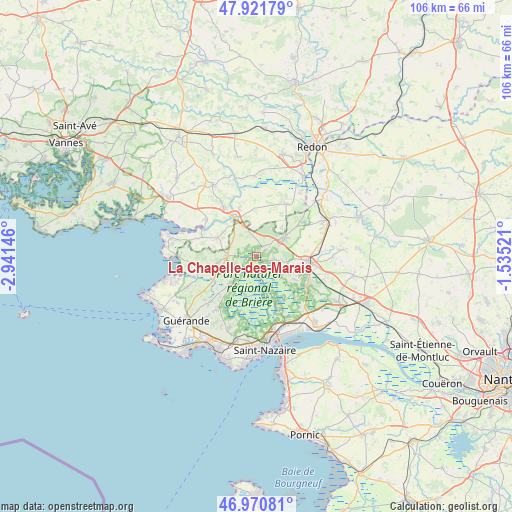
La Chapelle-des-Marais GPS coordinates[2]
47° 26' 54.42" North, 2° 14' 18.024" West
| Map corner | latitude | longitude |
|---|---|---|
| Upper-left | 47.92179°, | -2.94146° |
| Center: | 47.44845°, | -2.23834° |
| Lower-right: | 46.97081°, | -1.53521° |
| Map W x H: | 105.7×105.7 km | = 65.7×65.7mi |
| max Lat: | 51.07786° ⇑49.5% North |
| La Chapelle-des-Marais: | 47.44845° |
| min Lat: | ⇓50.5% South 41.3874° |
| min Long | La Chapelle-des | max Long |
| -5.08615° | -2.23834° | 9.52242° |
| W 4.4%⇐ | ⇒95.6% E |
Elevation
Elevation of La Chapelle-des-Marais is 6 m = 20 ft, and this is 187.7 m = 616 ft below average elevation for this country.
| Max E: |
2333 m = 7654 ft | 99% |
| Avg. | 193.7 m = 635 ft | |
| La Chapelle-des-Marais | 6 m = 20 ft | |
Min E: |
-1 m = -3 ft | 1% |
See also: France elevation on elevation.city.
Geographical zone
La Chapelle-des-Marais is located in North temperate zone (between Tropic of Cancer and the Arctic Circle). Distance of this North polar circle is 2125.4 km =1320.7 mi to North.| Distance of | km | miles | from La Chapelle-des-Marais |
|---|---|---|---|
| North Pole | 4731.3 | 2939.9 | to North |
| Arctic Circle | 2125.4 | 1320.7 | to North |
| Tropic Cancer | 2669.9 | 1659 | to South |
| Equator | 5275.8 | 3278.2 | to South |


Nearby cities:
15 places around La Chapelle-des-Marais: (largest is in red/bold)
• Assérac
11.6 km =7.2 mi,  259°
259°
• Crossac
6.6 km =4.1 mi,  128°
128°
• Férel
8.7 km =5.4 mi,  295°
295°
• Herbignac
6 km =3.7 mi,  269°
269°
• La Roche-Bernard
9.2 km =5.7 mi,  328°
328°
• Le Pin
12.2 km =7.6 mi,  153°
153°
• Marzan
12.1 km =7.5 mi, 327°
• Missillac
6.9 km =4.3 mi,  57°
57°
• Nivillac
10.1 km =6.3 mi,  340°
340°
• Pontchâteau
11.2 km =7 mi,  95°
95°
• Saint-Dolay
12.4 km =7.7 mi,  30°
30°
• Saint-Joachim
8 km =5 mi, 154°
• Saint-Lyphard
7.6 km =4.7 mi,  222°
222°
• Saint-Malo-de-Guersac
11.5 km =7.1 mi,  156°
156°
• Sainte-Reine-de-Bretagne
3.5 km =2.2 mi, 102°
Sources, notices
• [Note1] Compared only with cities in France existing in our database
• [Src1] Map data: © OpenStreetMap contributors (CC-BY-SA)
• [Src2] Other city data from geonames.org with taken over terms of usage.
• [Src3] Geographical zone / Annual Mean Temperature by Robert A. Rohde @ Wikipedia
