Saint-Lubin-en-Vergonnois geodata
Saint-Lubin-en-Vergonnois (Centre) is a populated place; located in France in Europe/Paris (GMT+2) time zone. With population of 776 people, there are 10868 cities with bigger population in this country. Compared to other cities in France, 52.8% of cities are located further ↓South; 66.3% of cities are located further →East and 63.2% of cities have higher elevation than Saint-Lubin-en-Vergonnois. Note1
Administrative division(s):
- Level 1: Centre
- Level 2: Département du Loir-et-Cher
- Level 3: Arrondissement de Blois
- Level 4: Saint-Lubin-en-Vergonnois
Current local time in Saint-Lubin-en-Vergonnois:
09:59 AM, SaturdayDifference from your time zone: hours


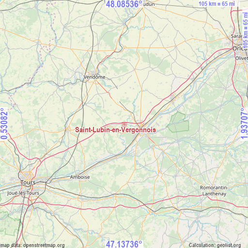
Saint-Lubin-en-Vergonnois GPS coordinates[2]
47° 36' 48.636" North, 1° 14' 2.22" East
| Map corner | latitude | longitude |
|---|---|---|
| Upper-left | 48.08536°, | 0.53082° |
| Center: | 47.61351°, | 1.23395° |
| Lower-right: | 47.13736°, | 1.93707° |
| Map W x H: | 105.4×105.4 km | = 65.5×65.5mi |
| max Lat: | 51.07786° ⇑47.2% North |
| Saint-Lubin-en-Vergonnois: | 47.61351° |
| min Lat: | ⇓52.8% South 41.3874° |
| min Long | Saint-Lubin-en- | max Long |
| -5.08615° | 1.23395° | 9.52242° |
| W 33.7%⇐ | ⇒66.3% E |
Elevation
Elevation of Saint-Lubin-en-Vergonnois is 94 m = 308 ft, and this is 99.7 m = 327 ft below average elevation for this country.
| Max E: |
2333 m = 7654 ft | 63.2% |
| Avg. | 193.7 m = 635 ft | |
| Saint-Lubin-en-Vergonnois | 94 m = 308 ft | |
Min E: |
-1 m = -3 ft | 36.8% |
See also: France elevation on elevation.city.
Geographical zone
Saint-Lubin-en-Vergonnois is located in North temperate zone (between Tropic of Cancer and the Arctic Circle). Distance of this North polar circle is 2107 km =1309.2 mi to North.| Distance of | km | miles | from Saint-Lubin-en-Vergonnois |
|---|---|---|---|
| North Pole | 4712.9 | 2928.5 | to North |
| Arctic Circle | 2107 | 1309.2 | to North |
| Tropic Cancer | 2688.2 | 1670.4 | to South |
| Equator | 5294.1 | 3289.6 | to South |


Nearby cities:
15 places around Saint-Lubin-en-Vergonnois: (largest is in red/bold)
• Averdon
9 km =5.6 mi,  30°
30°
• Blois
7.4 km =4.6 mi,  106°
106°
• Chailles
9.9 km =6.2 mi,  143°
143°
• Chambon-sur-Cisse
5.8 km =3.6 mi,  193°
193°
• Chouzy-sur-Cisse
9.8 km =6.1 mi,  174°
174°
• Fossé
4.4 km =2.7 mi,  59°
59°
• Herbault
7.2 km =4.5 mi,  262°
262°
• La Chapelle-Vendômoise
6.4 km =4 mi,  3°
3°
• La Chaussée-Saint-Victor
10 km =6.2 mi,  88°
88°
• Landes-le-Gaulois
5.8 km =3.6 mi,  320°
320°
• Marolles
6.7 km =4.2 mi,  54°
54°
• Molineuf
4.2 km =2.6 mi,  196°
196°
• Orchaise
3.7 km =2.3 mi,  226°
226°
• Saint-Sulpice-de-Pommeray
2.9 km =1.8 mi,  121°
121°
• Villebarou
6.7 km =4.2 mi,  80°
80°
Sources, notices
• [Note1] Compared only with cities in France existing in our database
• [Src1] Map data: © OpenStreetMap contributors (CC-BY-SA)
• [Src2] Other city data from geonames.org with taken over terms of usage.
• [Src3] Geographical zone / Annual Mean Temperature by Robert A. Rohde @ Wikipedia
