Chambretaud geodata
Chambretaud (Pays de la Loire) is a populated place; located in France in Europe/Paris (GMT+2) time zone. With population of 1,377 people, there are 6691 cities with bigger population in this country. Compared to other cities in France, 56.1% of cities are located further ↑North; 87.9% of cities are located further →East and 67.2% of cities have lower elevation than Chambretaud. Note1
Administrative division(s):
- Level 1: Pays de la Loire
- Level 2: Département de la Vendée
- Level 3: Arrondissement de La Roche-sur-Yon
- Level 4: Chanverrie


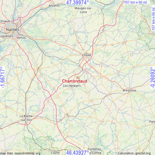
Chambretaud GPS coordinates[2]
46° 55' 17.976" North, 0° 57' 50.58" West
| Map corner | latitude | longitude |
|---|---|---|
| Upper-left | 47.39974°, | -1.66717° |
| Center: | 46.92166°, | -0.96405° |
| Lower-right: | 46.43927°, | -0.26092° |
| Map W x H: | 106.8×106.8 km | = 66.4×66.4mi |
| max Lat: | 51.07786° ⇑56.1% North |
| Chambretaud: | 46.92166° |
| min Lat: | ⇓43.9% South 41.3874° |
| min Long | Chambretaud | max Long |
| -5.08615° | -0.96405° | 9.52242° |
| W 12.1%⇐ | ⇒87.9% E |
Elevation
Elevation of Chambretaud is 205 m = 673 ft, and this is 11.3 m = 37 ft above average elevation for this country.
| Max E: |
2333 m = 7654 ft | 32.8% |
| Chambretaud | 205 m 673 ft | |
| Avg. | 193.7 m = 635 ft | |
Min E: |
-1 m = -3 ft | 67.2% |
See also: France elevation on elevation.city.
Geographical zone
Chambretaud is located in North temperate zone (between Tropic of Cancer and the Arctic Circle). Distance of this North polar circle is 2184 km =1357.1 mi to North.| Distance of | km | miles | from Chambretaud |
|---|---|---|---|
| North Pole | 4789.9 | 2976.3 | to North |
| Arctic Circle | 2184 | 1357.1 | to North |
| Tropic Cancer | 2611.3 | 1622.6 | to South |
| Equator | 5217.2 | 3241.8 | to South |


Nearby cities:
15 places around Chambretaud: (largest is in red/bold)
• Beaurepaire
9.6 km =6 mi,  262°
262°
• La Gaubretière
7.8 km =4.8 mi,  286°
286°
• La Verrie
5 km =3.1 mi,  331°
331°
• Les Epesses
6.5 km =4 mi,  131°
131°
• Les Herbiers
7.3 km =4.5 mi,  213°
213°
• Mortagne-sur-Sèvre
7.9 km =4.9 mi,  9°
9°
• Saint-Aubin-des-Ormeaux
9.9 km =6.2 mi,  322°
322°
• Saint-Christophe-du-Bois
12.2 km =7.6 mi, 7°
• Saint-Laurent-sur-Sèvre
6.7 km =4.2 mi,  52°
52°
• Saint-Malô-du-Bois
5 km =3.1 mi,  75°
75°
• Saint-Mars-la-Réorthe
7.3 km =4.5 mi,  155°
155°
• Saint-Martin-des-Tilleuls
8.7 km =5.4 mi,  311°
311°
• Saint-Michel-Mont-Mercure
12 km =7.5 mi,  149°
149°
• Saint-Paul-en-Pareds
11.2 km =7 mi,  190°
190°
• Treize-Vents
8.8 km =5.5 mi,  90°
90°
Sources, notices
• [Note1] Compared only with cities in France existing in our database
• [Src1] Map data: © OpenStreetMap contributors (CC-BY-SA)
• [Src2] Other city data from geonames.org with taken over terms of usage.
• [Src3] Geographical zone / Annual Mean Temperature by Robert A. Rohde @ Wikipedia
