La Mure geodata
La Mure (Auvergne-Rhône-Alpes) is a populated place; located in France in Europe/Paris (GMT+2) time zone. With population of 5,190 people, there are 1899 cities with bigger population in this country. Compared to other cities in France, 80.5% of cities are located further ↑North; 85.1% of cities are located further ←West and 98% of cities have lower elevation than La Mure. Note1
Administrative division(s):
- Level 1: Auvergne-Rhône-Alpes
- Level 2: Département de l'Isère
- Level 3: Arrondissement de Grenoble
- Level 4: La Mure


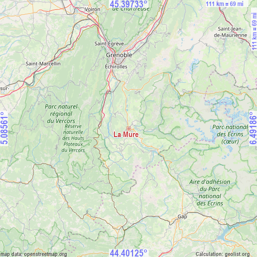
La Mure GPS coordinates[2]
44° 54' 5.22" North, 5° 47' 19.464" East
| Map corner | latitude | longitude |
|---|---|---|
| Upper-left | 45.39733°, | 5.08561° |
| Center: | 44.90145°, | 5.78874° |
| Lower-right: | 44.40125°, | 6.49186° |
| Map W x H: | 110.8×110.8 km | = 68.8×68.8mi |
| max Lat: | 51.07786° ⇑80.5% North |
| La Mure: | 44.90145° |
| min Lat: | ⇓19.5% South 41.3874° |
| min Long | La Mure | max Long |
| -5.08615° | 5.78874° | 9.52242° |
| W 85.1%⇐ | ⇒14.9% E |
Elevation
Elevation of La Mure is 822 m = 2697 ft, and this is 628.3 m = 2061 ft above average elevation for this country.
| Max E: |
2333 m = 7654 ft | 2% |
| La Mure | 822 m 2697 ft | |
| Avg. | 193.7 m = 635 ft | |
Min E: |
-1 m = -3 ft | 98% |
See also: France elevation on elevation.city.
Geographical zone
La Mure is located in North temperate zone (between Tropic of Cancer and the Arctic Circle). Distance of this Northern Tropic circle is 2386.7 km =1483 mi to South.| Distance of | km | miles | from La Mure |
|---|---|---|---|
| North Pole | 5014.5 | 3115.9 | to North |
| Arctic Circle | 2408.6 | 1496.6 | to North |
| Tropic Cancer | 2386.7 | 1483 | to South |
| Equator | 4992.6 | 3102.3 | to South |


Nearby cities:
15 places around La Mure: (largest is in red/bold)
• Champ-sur-Drac
19.2 km =11.9 mi,  346°
346°
• La Motte-Saint-Martin
7.9 km =4.9 mi,  314°
314°
• La Motte-d’Aveillans
7.4 km =4.6 mi,  331°
331°
• Le Gua
18.6 km =11.6 mi, 313°
• Mens
10 km =6.2 mi,  197°
197°
• Monestier-de-Clermont
12.3 km =7.6 mi,  278°
278°
• Notre-Dame-de-Mésage
18.1 km =11.2 mi, 352°
• Pierre-Châtel
6.3 km =3.9 mi, 349°
• Saint-Barthélemy
16.6 km =10.3 mi, 311°
• Saint-Barthélemy-de-Séchilienne
16.7 km =10.4 mi,  10°
10°
• Saint-Georges-de-Commiers
17.3 km =10.7 mi,  337°
337°
• Saint-Honoré
5.1 km =3.2 mi,  25°
25°
• Saint-Pierre-de-Mésage
16.1 km =10 mi,  0°
0°
• Sinard
11.4 km =7.1 mi,  295°
295°
• Séchilienne
17.7 km =11 mi, 11°
Sources, notices
• [Note1] Compared only with cities in France existing in our database
• [Src1] Map data: © OpenStreetMap contributors (CC-BY-SA)
• [Src2] Other city data from geonames.org with taken over terms of usage.
• [Src3] Geographical zone / Annual Mean Temperature by Robert A. Rohde @ Wikipedia
