Saint-Herblon geodata
Saint-Herblon (Pays de la Loire) is a populated place; located in France in Europe/Paris (GMT+2) time zone. With population of 1,950 people, there are 4910 cities with bigger population in this country. Compared to other cities in France, 50% of cities are located further ↓South; 89.1% of cities are located further →East and 77.8% of cities have higher elevation than Saint-Herblon. Note1
Administrative division(s):
- Level 1: Pays de la Loire
- Level 2: Loire-Atlantique
- Level 3: Arrondissement of Châteaubriant-Ancenis
- Level 4: Vair-sur-Loire


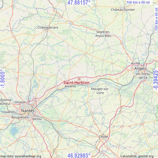
Saint-Herblon GPS coordinates[2]
47° 24' 28.296" North, 1° 5' 50.568" West
| Map corner | latitude | longitude |
|---|---|---|
| Upper-left | 47.88157°, | -1.8005° |
| Center: | 47.40786°, | -1.09738° |
| Lower-right: | 46.92985°, | -0.39425° |
| Map W x H: | 105.8×105.8 km | = 65.7×65.7mi |
| max Lat: | 51.07786° ⇑50% North |
| Saint-Herblon: | 47.40786° |
| min Lat: | ⇓50% South 41.3874° |
| min Long | Saint-Herblon | max Long |
| -5.08615° | -1.09738° | 9.52242° |
| W 10.9%⇐ | ⇒89.1% E |
Elevation
Elevation of Saint-Herblon is 60 m = 197 ft, and this is 133.7 m = 439 ft below average elevation for this country.
| Max E: |
2333 m = 7654 ft | 77.8% |
| Avg. | 193.7 m = 635 ft | |
| Saint-Herblon | 60 m = 197 ft | |
Min E: |
-1 m = -3 ft | 22.2% |
See also: France elevation on elevation.city.
Geographical zone
Saint-Herblon is located in North temperate zone (between Tropic of Cancer and the Arctic Circle). Distance of this North polar circle is 2129.9 km =1323.5 mi to North.| Distance of | km | miles | from Saint-Herblon |
|---|---|---|---|
| North Pole | 4735.8 | 2942.7 | to North |
| Arctic Circle | 2129.9 | 1323.5 | to North |
| Tropic Cancer | 2665.3 | 1656.1 | to South |
| Equator | 5271.3 | 3275.4 | to South |


Nearby cities:
15 places around Saint-Herblon: (largest is in red/bold)
• Ancenis
6.9 km =4.3 mi,  228°
228°
• Anetz
3.1 km =1.9 mi,  191°
191°
• Belligné
8.5 km =5.3 mi,  38°
38°
• Bouzillé
7.9 km =4.9 mi, 187°
• La Chapelle-Saint-Florent
8.8 km =5.5 mi,  159°
159°
• La Chapelle-Saint-Sauveur
9.3 km =5.8 mi,  66°
66°
• La Roche-Blanche
4.8 km =3 mi,  318°
318°
• La Rouxière
4.5 km =2.8 mi,  31°
31°
• Le Marillais
5.8 km =3.6 mi, 164°
• Liré
8.8 km =5.5 mi,  215°
215°
• Maumusson
8.3 km =5.2 mi,  355°
355°
• Pouillé-les-Côteaux
7.2 km =4.5 mi, 317°
• Saint-Florent-le-Vieil
8.1 km =5 mi,  130°
130°
• Saint-Géréon
9.1 km =5.7 mi,  240°
240°
• Varades
5.8 km =3.6 mi,  116°
116°
Sources, notices
• [Note1] Compared only with cities in France existing in our database
• [Src1] Map data: © OpenStreetMap contributors (CC-BY-SA)
• [Src2] Other city data from geonames.org with taken over terms of usage.
• [Src3] Geographical zone / Annual Mean Temperature by Robert A. Rohde @ Wikipedia
