Chatou geodata
Chatou (Île-de-France) is a populated place; located in France in Europe/Paris (GMT+2) time zone. With population of 30,091 people, there are 269 cities with bigger population in this country. Compared to other cities in France, 77.4% of cities are located further ↓South; 55% of cities are located further →East and 87.4% of cities have higher elevation than Chatou. Note1
Administrative division(s):
- Level 1: Île-de-France
- Level 2: Yvelines
- Level 3: Arrondissement de Saint-Germain-en-Laye
- Level 4: Chatou


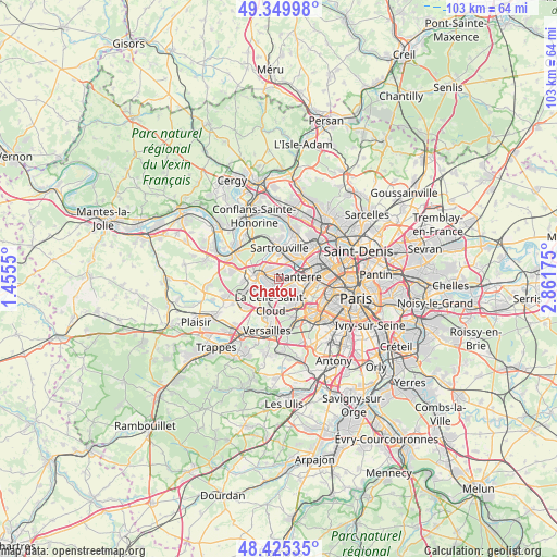
Chatou GPS coordinates[2]
48° 53' 23.28" North, 2° 9' 31.068" East
| Map corner | latitude | longitude |
|---|---|---|
| Upper-left | 49.34998°, | 1.4555° |
| Center: | 48.8898°, | 2.15863° |
| Lower-right: | 48.42535°, | 2.86175° |
| Map W x H: | 102.8×102.8 km | = 63.9×63.9mi |
| max Lat: | 51.07786° ⇑22.6% North |
| Chatou: | 48.8898° |
| min Lat: | ⇓77.4% South 41.3874° |
| min Long | Chatou | max Long |
| -5.08615° | 2.15863° | 9.52242° |
| W 45%⇐ | ⇒55% E |
Elevation
Elevation of Chatou is 36 m = 118 ft, and this is 157.7 m = 517 ft below average elevation for this country.
| Max E: |
2333 m = 7654 ft | 87.4% |
| Avg. | 193.7 m = 635 ft | |
| Chatou | 36 m = 118 ft | |
Min E: |
-1 m = -3 ft | 12.6% |
See also: France elevation on elevation.city.
Geographical zone
Chatou is located in North temperate zone (between Tropic of Cancer and the Arctic Circle). Distance of this North polar circle is 1965.1 km =1221.1 mi to North.| Distance of | km | miles | from Chatou |
|---|---|---|---|
| North Pole | 4571 | 2840.3 | to North |
| Arctic Circle | 1965.1 | 1221.1 | to North |
| Tropic Cancer | 2830.1 | 1758.5 | to South |
| Equator | 5436 | 3377.8 | to South |


Nearby cities:
15 places around Chatou: (largest is in red/bold)
• Bezons
5.5 km =3.4 mi,  45°
45°
• Bougival
3.3 km =2.1 mi,  202°
202°
• Carrières-sur-Seine
2.4 km =1.5 mi,  38°
38°
• Croissy-sur-Seine
1.9 km =1.2 mi,  231°
231°
• Houilles
4.3 km =2.7 mi, 35°
• La Celle-Saint-Cloud
4.5 km =2.8 mi,  192°
192°
• Le Pecq
4 km =2.5 mi,  275°
275°
• Le Port-Marly
3.5 km =2.2 mi,  270°
270°
• Le Vésinet
1.9 km =1.2 mi, 280°
• Louveciennes
4.5 km =2.8 mi, 225°
• Montesson
2.7 km =1.7 mi,  324°
324°
• Nanterre
3.5 km =2.2 mi,  86°
86°
• Rueil-Malmaison
2.7 km =1.7 mi,  123°
123°
• Saint-Germain-en-Laye
5 km =3.1 mi, 278°
• Vaucresson
5.5 km =3.4 mi,  181°
181°
Sources, notices
• [Note1] Compared only with cities in France existing in our database
• [Src1] Map data: © OpenStreetMap contributors (CC-BY-SA)
• [Src2] Other city data from geonames.org with taken over terms of usage.
• [Src3] Geographical zone / Annual Mean Temperature by Robert A. Rohde @ Wikipedia
