Bougival geodata
Bougival (Île-de-France) is a populated place; located in France in Europe/Paris (GMT+1) time zone. With population of 8,895 people, there are 1080 cities with bigger population in this country. Compared to other cities in France, 76.9% of cities are located further ↓South; 55.2% of cities are located further →East and 66% of cities have higher elevation than Bougival. Note1
Administrative division(s):
- Level 1: Île-de-France
- Level 2: Yvelines
- Level 3: Arrondissement de Versailles
- Level 4: Bougival


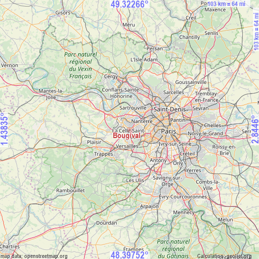
Bougival GPS coordinates[2]
48° 51' 44.028" North, 2° 8' 29.328" East
| Map corner | latitude | longitude |
|---|---|---|
| Upper-left | 49.32266°, | 1.43835° |
| Center: | 48.86223°, | 2.14148° |
| Lower-right: | 48.39752°, | 2.8446° |
| Map W x H: | 102.9×102.9 km | = 63.9×63.9mi |
| max Lat: | 51.07786° ⇑23.1% North |
| Bougival: | 48.86223° |
| min Lat: | ⇓76.9% South 41.3874° |
| min Long | Bougival | max Long |
| -5.08615° | 2.14148° | 9.52242° |
| W 44.8%⇐ | ⇒55.2% E |
Elevation
Elevation of Bougival is 87 m = 285 ft, and this is 106.7 m = 350 ft below average elevation for this country.
| Max E: |
2333 m = 7654 ft | 66% |
| Avg. | 193.7 m = 635 ft | |
| Bougival | 87 m = 285 ft | |
Min E: |
-1 m = -3 ft | 34% |
See also: France elevation on elevation.city.
Geographical zone
Bougival is located in North temperate zone (between Tropic of Cancer and the Arctic Circle). Distance of this North polar circle is 1968.2 km =1223 mi to North.| Distance of | km | miles | from Bougival |
|---|---|---|---|
| North Pole | 4574.1 | 2842.2 | to North |
| Arctic Circle | 1968.2 | 1223 | to North |
| Tropic Cancer | 2827.1 | 1756.7 | to South |
| Equator | 5433 | 3375.9 | to South |


Nearby cities:
15 places around Bougival: (largest is in red/bold)
• Chatou
3.3 km =2.1 mi,  22°
22°
• Croissy-sur-Seine
1.9 km =1.2 mi,  353°
353°
• Garches
3.7 km =2.3 mi,  126°
126°
• La Celle-Saint-Cloud
1.4 km =0.9 mi,  168°
168°
• Le Chesnay
4.7 km =2.9 mi,  197°
197°
• Le Pecq
4.4 km =2.7 mi,  321°
321°
• Le Port-Marly
3.8 km =2.4 mi, 324°
• Le Vésinet
3.5 km =2.2 mi, 349°
• Louveciennes
2 km =1.2 mi,  266°
266°
• Marly-le-Roi
4.3 km =2.7 mi,  276°
276°
• Marnes-la-Coquette
4.5 km =2.8 mi,  150°
150°
• Rocquencourt
3.9 km =2.4 mi,  226°
226°
• Rueil-Malmaison
3.9 km =2.4 mi,  65°
65°
• Saint-Cloud
4.8 km =3 mi,  111°
111°
• Vaucresson
2.6 km =1.6 mi,  155°
155°
Sources, notices
• [Note1] Compared only with cities in France existing in our database
• [Src1] Map data: © OpenStreetMap contributors (CC-BY-SA)
• [Src2] Other city data from geonames.org with taken over terms of usage.
• [Src3] Geographical zone / Annual Mean Temperature by Robert A. Rohde @ Wikipedia
