Saint-Genou geodata
Saint-Genou (Centre) is a populated place; located in France in Europe/Paris (GMT+2) time zone. With population of 978 people, there are 8995 cities with bigger population in this country. Compared to other cities in France, 56% of cities are located further ↑North; 65.2% of cities are located further →East and 59.1% of cities have higher elevation than Saint-Genou. Note1
Administrative division(s):
- Level 1: Centre
- Level 2: Département de l'Indre
- Level 3: Arrondissement de Châteauroux
- Level 4: Saint-Genou


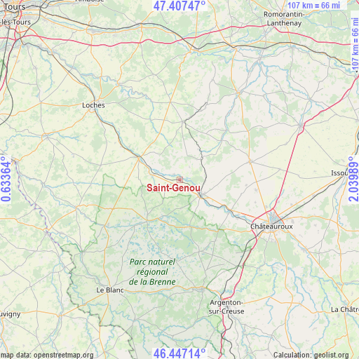
Saint-Genou GPS coordinates[2]
46° 55' 46.056" North, 1° 20' 12.336" East
| Map corner | latitude | longitude |
|---|---|---|
| Upper-left | 47.40747°, | 0.63364° |
| Center: | 46.92946°, | 1.33676° |
| Lower-right: | 46.44714°, | 2.03989° |
| Map W x H: | 106.8×106.8 km | = 66.4×66.4mi |
| max Lat: | 51.07786° ⇑56% North |
| Saint-Genou: | 46.92946° |
| min Lat: | ⇓44% South 41.3874° |
| min Long | Saint-Genou | max Long |
| -5.08615° | 1.33676° | 9.52242° |
| W 34.8%⇐ | ⇒65.2% E |
Elevation
Elevation of Saint-Genou is 105 m = 344 ft, and this is 88.7 m = 291 ft below average elevation for this country.
| Max E: |
2333 m = 7654 ft | 59.1% |
| Avg. | 193.7 m = 635 ft | |
| Saint-Genou | 105 m = 344 ft | |
Min E: |
-1 m = -3 ft | 40.9% |
See also: France elevation on elevation.city.
Geographical zone
Saint-Genou is located in North temperate zone (between Tropic of Cancer and the Arctic Circle). Distance of this North polar circle is 2183.1 km =1356.5 mi to North.| Distance of | km | miles | from Saint-Genou |
|---|---|---|---|
| North Pole | 4789 | 2975.7 | to North |
| Arctic Circle | 2183.1 | 1356.5 | to North |
| Tropic Cancer | 2612.1 | 1623.1 | to South |
| Equator | 5218.1 | 3242.4 | to South |


Nearby cities:
15 places around Saint-Genou: (largest is in red/bold)
• Argy
7.8 km =4.8 mi,  80°
80°
• Buzançais
7.7 km =4.8 mi,  125°
125°
• Châtillon-sur-Indre
14.1 km =8.8 mi,  297°
297°
• Clion
8 km =5 mi,  279°
279°
• Fléré-la-Rivière
20.1 km =12.5 mi, 300°
• Levroux
21.6 km =13.4 mi, 75°
• Loché-sur-Indrois
20.1 km =12.5 mi,  333°
333°
• Mézières-en-Brenne
15.5 km =9.6 mi,  218°
218°
• Neuillay-les-Bois
21 km =13 mi,  149°
149°
• Niherne
20.6 km =12.8 mi,  123°
123°
• Palluau-sur-Indre
2.3 km =1.4 mi,  308°
308°
• Pellevoisin
8.5 km =5.3 mi,  45°
45°
• Vendœuvres
14.4 km =8.9 mi,  176°
176°
• Villedieu-sur-Indre
18 km =11.2 mi, 121°
• Écueillé
17.3 km =10.7 mi,  2°
2°
Sources, notices
• [Note1] Compared only with cities in France existing in our database
• [Src1] Map data: © OpenStreetMap contributors (CC-BY-SA)
• [Src2] Other city data from geonames.org with taken over terms of usage.
• [Src3] Geographical zone / Annual Mean Temperature by Robert A. Rohde @ Wikipedia
