Écueillé geodata
Écueillé (Centre) is a populated place; located in France in Europe/Paris (GMT+2) time zone. With population of 1,343 people, there are 6854 cities with bigger population in this country. Compared to other cities in France, 54.4% of cities are located further ↑North; 65.1% of cities are located further →East and 53.1% of cities have lower elevation than Écueillé. Note1
Administrative division(s):
- Level 1: Centre
- Level 2: Département de l'Indre
- Level 3: Arrondissement de Châteauroux
- Level 4: Écueillé


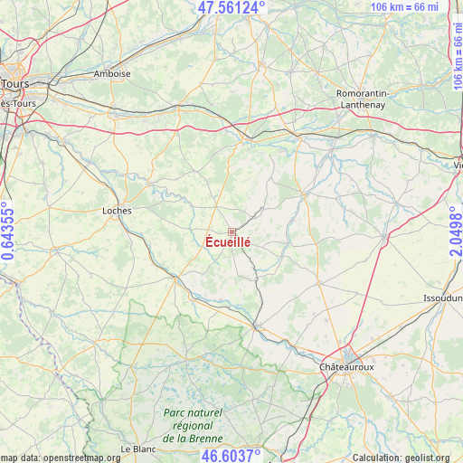
Écueillé GPS coordinates[2]
47° 5' 4.632" North, 1° 20' 48.048" East
| Map corner | latitude | longitude |
|---|---|---|
| Upper-left | 47.56124°, | 0.64355° |
| Center: | 47.08462°, | 1.34668° |
| Lower-right: | 46.6037°, | 2.0498° |
| Map W x H: | 106.5×106.5 km | = 66.2×66.2mi |
| max Lat: | 51.07786° ⇑54.4% North |
| Écueillé: | 47.08462° |
| min Lat: | ⇓45.6% South 41.3874° |
| min Long | Écueillé | max Long |
| -5.08615° | 1.34668° | 9.52242° |
| W 34.9%⇐ | ⇒65.1% E |
Elevation
Elevation of Écueillé is 143 m = 469 ft, and this is 50.7 m = 166 ft below average elevation for this country.
| Max E: |
2333 m = 7654 ft | 46.9% |
| Avg. | 193.7 m = 635 ft | |
| Écueillé | 143 m = 469 ft | |
Min E: |
-1 m = -3 ft | 53.1% |
See also: France elevation on elevation.city.
Geographical zone
Écueillé is located in North temperate zone (between Tropic of Cancer and the Arctic Circle). Distance of this North polar circle is 2165.9 km =1345.8 mi to North.| Distance of | km | miles | from Écueillé |
|---|---|---|---|
| North Pole | 4771.7 | 2965 | to North |
| Arctic Circle | 2165.9 | 1345.8 | to North |
| Tropic Cancer | 2629.4 | 1633.8 | to South |
| Equator | 5235.3 | 3253.1 | to South |


Nearby cities:
15 places around Écueillé: (largest is in red/bold)
• Argy
17.4 km =10.8 mi,  156°
156°
• Baudres
17.8 km =11.1 mi,  99°
99°
• Châteauvieux
16.5 km =10.3 mi,  9°
9°
• Châtillon-sur-Indre
17.1 km =10.6 mi,  230°
230°
• Clion
18.2 km =11.3 mi,  208°
208°
• Loché-sur-Indrois
9.6 km =6 mi,  274°
274°
• Luçay-le-Mâle
8.8 km =5.5 mi,  54°
54°
• Nouans-les-Fontaines
6.8 km =4.2 mi,  327°
327°
• Orbigny
16.3 km =10.1 mi, 328°
• Palluau-sur-Indre
16 km =9.9 mi,  189°
189°
• Pellevoisin
12.4 km =7.7 mi,  154°
154°
• Saint-Genou
17.3 km =10.7 mi,  182°
182°
• Vicq-sur-Nahon
14.7 km =9.1 mi,  80°
80°
• Villeloin-Coulangé
11.2 km =7 mi,  303°
303°
• Villentrois
15 km =9.3 mi,  35°
35°
Sources, notices
• [Note1] Compared only with cities in France existing in our database
• [Src1] Map data: © OpenStreetMap contributors (CC-BY-SA)
• [Src2] Other city data from geonames.org with taken over terms of usage.
• [Src3] Geographical zone / Annual Mean Temperature by Robert A. Rohde @ Wikipedia
