Buzançais geodata
Buzançais (Centre) is a populated place; located in France in Europe/Paris (GMT+2) time zone. With population of 4,600 people, there are 2148 cities with bigger population in this country. Compared to other cities in France, 56.3% of cities are located further ↑North; 64% of cities are located further →East and 58.3% of cities have higher elevation than Buzançais. Note1
Administrative division(s):
- Level 1: Centre
- Level 2: Département de l'Indre
- Level 3: Arrondissement de Châteauroux
- Level 4: Buzançais


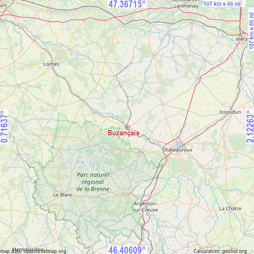
Buzançais GPS coordinates[2]
46° 53' 19.572" North, 1° 25' 10.2" East
| Map corner | latitude | longitude |
|---|---|---|
| Upper-left | 47.36715°, | 0.71637° |
| Center: | 46.88877°, | 1.4195° |
| Lower-right: | 46.40609°, | 2.12263° |
| Map W x H: | 106.9×106.9 km | = 66.4×66.4mi |
| max Lat: | 51.07786° ⇑56.3% North |
| Buzançais: | 46.88877° |
| min Lat: | ⇓43.7% South 41.3874° |
| min Long | Buzançais | max Long |
| -5.08615° | 1.4195° | 9.52242° |
| W 36%⇐ | ⇒64% E |
Elevation
Elevation of Buzançais is 107 m = 351 ft, and this is 86.7 m = 284 ft below average elevation for this country.
| Max E: |
2333 m = 7654 ft | 58.3% |
| Avg. | 193.7 m = 635 ft | |
| Buzançais | 107 m = 351 ft | |
Min E: |
-1 m = -3 ft | 41.7% |
See also: France elevation on elevation.city.
Geographical zone
Buzançais is located in North temperate zone (between Tropic of Cancer and the Arctic Circle). Distance of this North polar circle is 2187.6 km =1359.3 mi to North.| Distance of | km | miles | from Buzançais |
|---|---|---|---|
| North Pole | 4793.5 | 2978.5 | to North |
| Arctic Circle | 2187.6 | 1359.3 | to North |
| Tropic Cancer | 2607.6 | 1620.3 | to South |
| Equator | 5213.5 | 3239.5 | to South |


Nearby cities:
15 places around Buzançais: (largest is in red/bold)
• Argy
6 km =3.7 mi,  13°
13°
• Châtillon-sur-Indre
21.7 km =13.5 mi,  300°
300°
• Clion
15.4 km =9.6 mi,  292°
292°
• Levroux
17.7 km =11 mi,  55°
55°
• Luant
20.3 km =12.6 mi,  148°
148°
• Mézières-en-Brenne
17.6 km =10.9 mi,  244°
244°
• Neuillay-les-Bois
14.3 km =8.9 mi,  162°
162°
• Niherne
12.9 km =8 mi,  121°
121°
• Palluau-sur-Indre
10.1 km =6.3 mi,  306°
306°
• Pellevoisin
10.5 km =6.5 mi,  358°
358°
• Saint-Genou
7.7 km =4.8 mi, 305°
• Saint-Maur
19 km =11.8 mi, 118°
• Vendœuvres
11.2 km =7 mi,  208°
208°
• Villedieu-sur-Indre
10.3 km =6.4 mi, 117°
• Vineuil
16.5 km =10.3 mi,  85°
85°
Sources, notices
• [Note1] Compared only with cities in France existing in our database
• [Src1] Map data: © OpenStreetMap contributors (CC-BY-SA)
• [Src2] Other city data from geonames.org with taken over terms of usage.
• [Src3] Geographical zone / Annual Mean Temperature by Robert A. Rohde @ Wikipedia
