Argy geodata
Argy (Centre) is a populated place; located in France in Europe/Paris (GMT+2) time zone. With population of 620 people, there are 12983 cities with bigger population in this country. Compared to other cities in France, 55.9% of cities are located further ↑North; 63.8% of cities are located further →East and 53.8% of cities have higher elevation than Argy. Note1
Administrative division(s):
- Level 1: Centre
- Level 2: Département de l'Indre
- Level 3: Arrondissement de Châteauroux
- Level 4: Argy


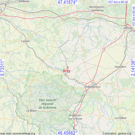
Argy GPS coordinates[2]
46° 56' 26.988" North, 1° 26' 17.628" East
| Map corner | latitude | longitude |
|---|---|---|
| Upper-left | 47.41874°, | 0.73511° |
| Center: | 46.94083°, | 1.43823° |
| Lower-right: | 46.45862°, | 2.14136° |
| Map W x H: | 106.8×106.8 km | = 66.4×66.4mi |
| max Lat: | 51.07786° ⇑55.9% North |
| Argy: | 46.94083° |
| min Lat: | ⇓44.1% South 41.3874° |
| min Long | Argy | max Long |
| -5.08615° | 1.43823° | 9.52242° |
| W 36.2%⇐ | ⇒63.8% E |
Elevation
Elevation of Argy is 120 m = 394 ft, and this is 73.7 m = 242 ft below average elevation for this country.
| Max E: |
2333 m = 7654 ft | 53.8% |
| Avg. | 193.7 m = 635 ft | |
| Argy | 120 m = 394 ft | |
Min E: |
-1 m = -3 ft | 46.2% |
See also: France elevation on elevation.city.
Geographical zone
Argy is located in North temperate zone (between Tropic of Cancer and the Arctic Circle). Distance of this North polar circle is 2181.8 km =1355.7 mi to North.| Distance of | km | miles | from Argy |
|---|---|---|---|
| North Pole | 4787.7 | 2974.9 | to North |
| Arctic Circle | 2181.8 | 1355.7 | to North |
| Tropic Cancer | 2613.4 | 1623.9 | to South |
| Equator | 5219.3 | 3243.1 | to South |


Nearby cities:
15 places around Argy: (largest is in red/bold)
• Baudres
16.8 km =10.4 mi,  39°
39°
• Buzançais
6 km =3.7 mi,  193°
193°
• Châtillon-sur-Indre
20.8 km =12.9 mi,  284°
284°
• Clion
15.6 km =9.7 mi,  270°
270°
• Levroux
13.9 km =8.6 mi,  72°
72°
• Neuillay-les-Bois
19.7 km =12.2 mi,  171°
171°
• Niherne
15.8 km =9.8 mi,  142°
142°
• Palluau-sur-Indre
9.5 km =5.9 mi, 271°
• Pellevoisin
5 km =3.1 mi,  340°
340°
• Saint-Genou
7.8 km =4.8 mi,  260°
260°
• Vendœuvres
17 km =10.6 mi,  203°
203°
• Vicq-sur-Nahon
19.9 km =12.4 mi,  22°
22°
• Villedieu-sur-Indre
13.1 km =8.1 mi, 143°
• Vineuil
15.6 km =9.7 mi,  106°
106°
• Écueillé
17.4 km =10.8 mi, 336°
Sources, notices
• [Note1] Compared only with cities in France existing in our database
• [Src1] Map data: © OpenStreetMap contributors (CC-BY-SA)
• [Src2] Other city data from geonames.org with taken over terms of usage.
• [Src3] Geographical zone / Annual Mean Temperature by Robert A. Rohde @ Wikipedia
