Saint-Chély-d’Apcher geodata
Saint-Chély-d’Apcher (Occitanie) is a populated place; located in France in Europe/Paris (GMT+2) time zone. With population of 4,160 people, there are 2360 cities with bigger population in this country. Compared to other cities in France, 81.3% of cities are located further ↑North; 61.7% of cities are located further ←West and 99.2% of cities have lower elevation than Saint-Chély-d’Apcher. Note1
Administrative division(s):
- Level 1: Occitanie
- Level 2: Département de la Lozère
- Level 3: Arrondissement de Mende
- Level 4: Saint-Chély-d'Apcher


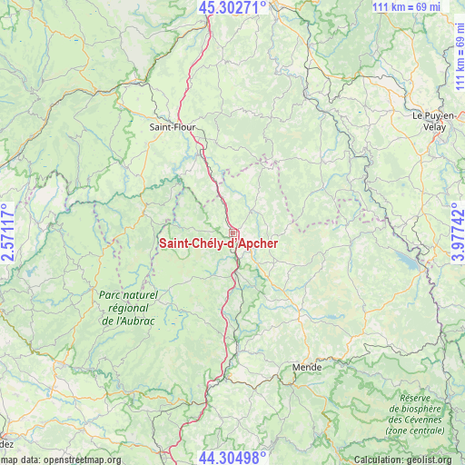
Saint-Chély-d’Apcher GPS coordinates[2]
44° 48' 21.6" North, 3° 16' 27.444" East
| Map corner | latitude | longitude |
|---|---|---|
| Upper-left | 45.30271°, | 2.57117° |
| Center: | 44.806°, | 3.27429° |
| Lower-right: | 44.30498°, | 3.97742° |
| Map W x H: | 110.9×110.9 km | = 68.9×68.9mi |
| max Lat: | 51.07786° ⇑81.3% North |
| Saint-Chély-d’Apcher: | 44.806° |
| min Lat: | ⇓18.7% South 41.3874° |
| min Long | Saint-Chély-d� | max Long |
| -5.08615° | 3.27429° | 9.52242° |
| W 61.7%⇐ | ⇒38.3% E |
Elevation
Elevation of Saint-Chély-d’Apcher is 1016 m = 3333 ft, and this is 822.3 m = 2698 ft above average elevation for this country.
| Max E: |
2333 m = 7654 ft | 0.8% |
| Saint-Chély-d’Apcher | 1016 m 3333 ft | |
| Avg. | 193.7 m = 635 ft | |
Min E: |
-1 m = -3 ft | 99.2% |
See also: France elevation on elevation.city.
Geographical zone
Saint-Chély-d’Apcher is located in North temperate zone (between Tropic of Cancer and the Arctic Circle). Distance of this Northern Tropic circle is 2376 km =1476.4 mi to South.| Distance of | km | miles | from Saint-Chély-d’Apcher |
|---|---|---|---|
| North Pole | 5025.1 | 3122.5 | to North |
| Arctic Circle | 2419.2 | 1503.2 | to North |
| Tropic Cancer | 2376 | 1476.4 | to South |
| Equator | 4982 | 3095.7 | to South |


Nearby cities:
15 places around Saint-Chély-d’Apcher: (largest is in red/bold)
• Aumont-Aubrac
9.4 km =5.8 mi,  174°
174°
• Chaudes-Aigues
22 km =13.7 mi,  284°
284°
• Grandrieu
28.5 km =17.7 mi,  94°
94°
• Le Malzieu-Ville
7.3 km =4.5 mi,  39°
39°
• Marvejols
28.1 km =17.5 mi,  177°
177°
• Montrodat
28.8 km =17.9 mi, 171°
• Nasbinals
24 km =14.9 mi,  228°
228°
• Neuvéglise
26.6 km =16.5 mi,  300°
300°
• Rieutort-de-Randon
25.3 km =15.7 mi,  139°
139°
• Rimeize
6 km =3.7 mi, 139°
• Saint-Alban-sur-Limagnole
9.4 km =5.8 mi,  107°
107°
• Saint-Flour
29.1 km =18.1 mi,  330°
330°
• Saint-Urcize
24.6 km =15.3 mi,  240°
240°
• Saugues
27.5 km =17.1 mi,  51°
51°
• Villedieu
27.1 km =16.8 mi,  322°
322°
Sources, notices
• [Note1] Compared only with cities in France existing in our database
• [Src1] Map data: © OpenStreetMap contributors (CC-BY-SA)
• [Src2] Other city data from geonames.org with taken over terms of usage.
• [Src3] Geographical zone / Annual Mean Temperature by Robert A. Rohde @ Wikipedia
