Sainte-Menehould geodata
Sainte-Menehould (Grand Est) is a seat of a third-order administrative division; located in France in Europe/Paris (GMT+2) time zone. With population of 5,237 people, there are 1879 cities with bigger population in this country. Compared to other cities in France, 81.9% of cities are located further ↓South; 76.4% of cities are located further ←West and 52.2% of cities have lower elevation than Sainte-Menehould. Note1
Administrative division(s):
- Level 1: Grand Est
- Level 2: Marne
- Level 3: Arrondissement de Châlons-en-Champagne
- Level 4: Sainte-Menehould


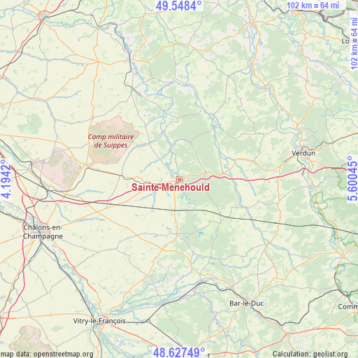
Sainte-Menehould GPS coordinates[2]
49° 5' 24.288" North, 4° 53' 50.388" East
| Map corner | latitude | longitude |
|---|---|---|
| Upper-left | 49.5484°, | 4.1942° |
| Center: | 49.09008°, | 4.89733° |
| Lower-right: | 48.62749°, | 5.60045° |
| Map W x H: | 102.4×102.4 km | = 63.6×63.6mi |
| max Lat: | 51.07786° ⇑18.1% North |
| Sainte-Menehould: | 49.09008° |
| min Lat: | ⇓81.9% South 41.3874° |
| min Long | Sainte-Menehoul | max Long |
| -5.08615° | 4.89733° | 9.52242° |
| W 76.4%⇐ | ⇒23.6% E |
Elevation
Elevation of Sainte-Menehould is 140 m = 459 ft, and this is 53.7 m = 176 ft below average elevation for this country.
| Max E: |
2333 m = 7654 ft | 47.8% |
| Avg. | 193.7 m = 635 ft | |
| Sainte-Menehould | 140 m = 459 ft | |
Min E: |
-1 m = -3 ft | 52.2% |
See also: France elevation on elevation.city.
Geographical zone
Sainte-Menehould is located in North temperate zone (between Tropic of Cancer and the Arctic Circle). Distance of this North polar circle is 1942.9 km =1207.3 mi to North.| Distance of | km | miles | from Sainte-Menehould |
|---|---|---|---|
| North Pole | 4548.8 | 2826.5 | to North |
| Arctic Circle | 1942.9 | 1207.3 | to North |
| Tropic Cancer | 2852.4 | 1772.4 | to South |
| Equator | 5458.3 | 3391.6 | to South |


Nearby cities:
15 places around Sainte-Menehould: (largest is in red/bold)
• Clermont-en-Argonne
12.7 km =7.9 mi,  81°
81°
• Contrisson
32.2 km =20 mi,  172°
172°
• Courtisols
30 km =18.6 mi,  247°
247°
• Givry-en-Argonne
15.6 km =9.7 mi,  182°
182°
• Grandpré
27.9 km =17.3 mi,  356°
356°
• Les Islettes
8 km =5 mi,  74°
74°
• L’Épine
33.5 km =20.8 mi, 248°
• Revigny-sur-Ornain
29.6 km =18.4 mi, 167°
• Sermaize-les-Bains
33.9 km =21.1 mi, 178°
• Seuil-d'Argonne
17.3 km =10.7 mi,  135°
135°
• Somme-Suippe
23.2 km =14.4 mi,  277°
277°
• Sommepy-Tahure
30.5 km =19 mi,  306°
306°
• Suippes
26.8 km =16.7 mi, 279°
• Varennes-en-Argonne
18.3 km =11.4 mi,  33°
33°
• Vienne-le-Château
11.3 km =7 mi, 356°
Sources, notices
• [Note1] Compared only with cities in France existing in our database
• [Src1] Map data: © OpenStreetMap contributors (CC-BY-SA)
• [Src2] Other city data from geonames.org with taken over terms of usage.
• [Src3] Geographical zone / Annual Mean Temperature by Robert A. Rohde @ Wikipedia
