Langon geodata
Langon (Brittany) is a populated place; located in France in Europe/Paris (GMT+2) time zone. With population of 1,411 people, there are 6559 cities with bigger population in this country. Compared to other cities in France, 54.6% of cities are located further ↓South; 94.3% of cities are located further →East and 93.1% of cities have higher elevation than Langon. Note1
Administrative division(s):
- Level 1: Brittany
- Level 2: Département d'Ille-et-Vilaine
- Level 3: Arrondissement de Redon
- Level 4: Langon


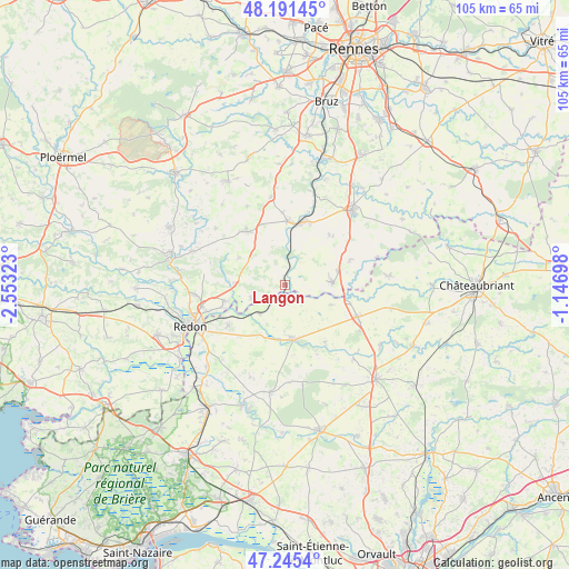
Langon GPS coordinates[2]
47° 43' 14.052" North, 1° 51' 0.36" West
| Map corner | latitude | longitude |
|---|---|---|
| Upper-left | 48.19145°, | -2.55323° |
| Center: | 47.72057°, | -1.8501° |
| Lower-right: | 47.2454°, | -1.14698° |
| Map W x H: | 105.2×105.2 km | = 65.4×65.4mi |
| max Lat: | 51.07786° ⇑45.4% North |
| Langon: | 47.72057° |
| min Lat: | ⇓54.6% South 41.3874° |
| min Long | Langon | max Long |
| -5.08615° | -1.8501° | 9.52242° |
| W 5.7%⇐ | ⇒94.3% E |
Elevation
Elevation of Langon is 22 m = 72 ft, and this is 171.7 m = 563 ft below average elevation for this country.
| Max E: |
2333 m = 7654 ft | 93.1% |
| Avg. | 193.7 m = 635 ft | |
| Langon | 22 m = 72 ft | |
Min E: |
-1 m = -3 ft | 6.9% |
See also: France elevation on elevation.city.
Geographical zone
Langon is located in North temperate zone (between Tropic of Cancer and the Arctic Circle). Distance of this North polar circle is 2095.1 km =1301.8 mi to North.| Distance of | km | miles | from Langon |
|---|---|---|---|
| North Pole | 4701 | 2921.1 | to North |
| Arctic Circle | 2095.1 | 1301.8 | to North |
| Tropic Cancer | 2700.1 | 1677.8 | to South |
| Equator | 5306 | 3297 | to South |


Nearby cities:
15 places around Langon: (largest is in red/bold)
• Avessac
12.8 km =8 mi,  234°
234°
• Conquereuil
12.9 km =8 mi,  145°
145°
• Derval
14.7 km =9.1 mi,  113°
113°
• Grand-Fougeray
8.8 km =5.5 mi,  87°
87°
• Guipry
11.8 km =7.3 mi,  2°
2°
• Guémené-Penfao
9.8 km =6.1 mi,  172°
172°
• La Dominelais
13 km =8.1 mi,  69°
69°
• La Noë-Blanche
12.3 km =7.6 mi,  41°
41°
• Messac
11.9 km =7.4 mi,  14°
14°
• Pierric
9.3 km =5.8 mi, 113°
• Pipriac
12.2 km =7.6 mi,  323°
323°
• Renac
9.4 km =5.8 mi,  269°
269°
• Saint-Just
9.7 km =6 mi,  301°
301°
• Sainte-Anne-sur-Vilaine
2.2 km =1.4 mi,  59°
59°
• Sainte-Marie
11.7 km =7.3 mi,  255°
255°
Sources, notices
• [Note1] Compared only with cities in France existing in our database
• [Src1] Map data: © OpenStreetMap contributors (CC-BY-SA)
• [Src2] Other city data from geonames.org with taken over terms of usage.
• [Src3] Geographical zone / Annual Mean Temperature by Robert A. Rohde @ Wikipedia
