Sainte-Gauburge-Sainte-Colombe geodata
Sainte-Gauburge-Sainte-Colombe (Normandy) is a populated place; located in France in Europe/Paris (GMT+2) time zone. With population of 1,263 people, there are 7214 cities with bigger population in this country. Compared to other cities in France, 73.6% of cities are located further ↓South; 74% of cities are located further →East and 73.2% of cities have lower elevation than Sainte-Gauburge-Sainte-Colombe. Note1
Administrative division(s):
- Level 1: Normandy
- Level 2: Département de l'Orne
- Level 3: Arrondissement de Mortagne-au-Perche
- Level 4: Sainte-Gauburge-Sainte-Colombe
Current local time in Sainte-Gauburge-Sainte-Colombe:
02:04 PM, SaturdayDifference from your time zone: hours


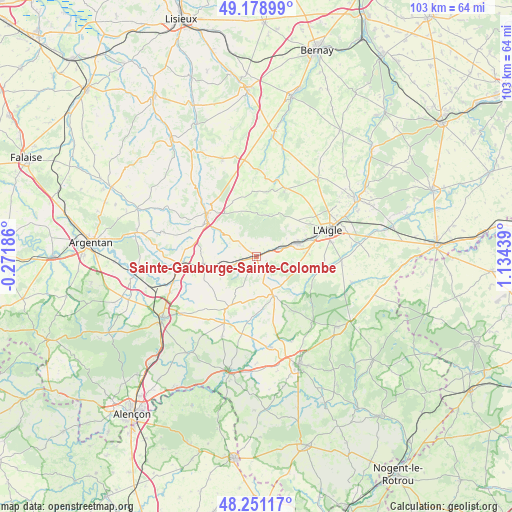
Sainte-Gauburge-Sainte-Colombe GPS coordinates[2]
48° 43' 1.992" North, 0° 25' 52.536" East
| Map corner | latitude | longitude |
|---|---|---|
| Upper-left | 49.17899°, | -0.27186° |
| Center: | 48.71722°, | 0.43126° |
| Lower-right: | 48.25117°, | 1.13439° |
| Map W x H: | 103.2×103.2 km | = 64.1×64.1mi |
| max Lat: | 51.07786° ⇑26.4% North |
| Sainte-Gauburge-Sainte-Colombe: | 48.71722° |
| min Lat: | ⇓73.6% South 41.3874° |
| min Long | Sainte-Gauburge | max Long |
| -5.08615° | 0.43126° | 9.52242° |
| W 26%⇐ | ⇒74% E |
Elevation
Elevation of Sainte-Gauburge-Sainte-Colombe is 237 m = 778 ft, and this is 43.3 m = 142 ft above average elevation for this country.
| Max E: |
2333 m = 7654 ft | 26.8% |
| Sainte-Gauburge-Sainte-Colombe | 237 m 778 ft | |
| Avg. | 193.7 m = 635 ft | |
Min E: |
-1 m = -3 ft | 73.2% |
See also: France elevation on elevation.city.
Geographical zone
Sainte-Gauburge-Sainte-Colombe is located in North temperate zone (between Tropic of Cancer and the Arctic Circle). Distance of this North polar circle is 1984.3 km =1233 mi to North.| Distance of | km | miles | from Sainte-Gauburge-Sainte-Colombe |
|---|---|---|---|
| North Pole | 4590.2 | 2852.2 | to North |
| Arctic Circle | 1984.3 | 1233 | to North |
| Tropic Cancer | 2810.9 | 1746.6 | to South |
| Equator | 5416.8 | 3365.8 | to South |


Nearby cities:
15 places around Sainte-Gauburge-Sainte-Colombe: (largest is in red/bold)
• Aube-sur-Rîle
9.2 km =5.7 mi,  74°
74°
• Courtomer
11.4 km =7.1 mi,  208°
208°
• Crulai
17.4 km =10.8 mi,  94°
94°
• Gacé
13 km =8.1 mi,  310°
310°
• La Ferté-Frênel
15 km =9.3 mi,  22°
22°
• Le Merlerault
10.8 km =6.7 mi,  260°
260°
• Moulins-la-Marche
8 km =5 mi,  156°
156°
• Nonant-le-Pin
15.5 km =9.6 mi,  265°
265°
• Rai
11.7 km =7.3 mi, 71°
• Saint-Hilaire-le-Châtel
18.6 km =11.6 mi, 157°
• Saint-Sulpice-sur-Risle
18 km =11.2 mi, 66°
• Saint-Symphorien-des-Bruyères
13.6 km =8.5 mi,  54°
54°
• Sainte-Scolasse-sur-Sarthe
15.9 km =9.9 mi,  190°
190°
• Soligny-la-Trappe
13.8 km =8.6 mi,  146°
146°
• Échauffour
4.1 km =2.5 mi, 309°
Sources, notices
• [Note1] Compared only with cities in France existing in our database
• [Src1] Map data: © OpenStreetMap contributors (CC-BY-SA)
• [Src2] Other city data from geonames.org with taken over terms of usage.
• [Src3] Geographical zone / Annual Mean Temperature by Robert A. Rohde @ Wikipedia
