Courtomer geodata
Courtomer (Normandy) is a populated place; located in France in Europe/Paris (GMT+2) time zone. With population of 686 people, there are 12000 cities with bigger population in this country. Compared to other cities in France, 71.5% of cities are located further ↓South; 74.8% of cities are located further →East and 67.4% of cities have lower elevation than Courtomer. Note1
Administrative division(s):
- Level 1: Normandy
- Level 2: Département de l'Orne
- Level 3: Arrondissement d’Alençon
- Level 4: Courtomer


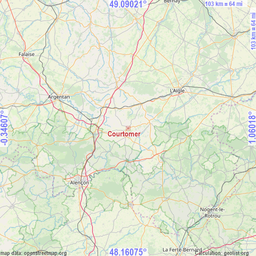
Courtomer GPS coordinates[2]
48° 37' 39.432" North, 0° 21' 25.416" East
| Map corner | latitude | longitude |
|---|---|---|
| Upper-left | 49.09021°, | -0.34607° |
| Center: | 48.62762°, | 0.35706° |
| Lower-right: | 48.16075°, | 1.06018° |
| Map W x H: | 103.3×103.3 km | = 64.2×64.2mi |
| max Lat: | 51.07786° ⇑28.5% North |
| Courtomer: | 48.62762° |
| min Lat: | ⇓71.5% South 41.3874° |
| min Long | Courtomer | max Long |
| -5.08615° | 0.35706° | 9.52242° |
| W 25.2%⇐ | ⇒74.8% E |
Elevation
Elevation of Courtomer is 206 m = 676 ft, and this is 12.3 m = 40 ft above average elevation for this country.
| Max E: |
2333 m = 7654 ft | 32.6% |
| Courtomer | 206 m 676 ft | |
| Avg. | 193.7 m = 635 ft | |
Min E: |
-1 m = -3 ft | 67.4% |
See also: France elevation on elevation.city.
Geographical zone
Courtomer is located in North temperate zone (between Tropic of Cancer and the Arctic Circle). Distance of this North polar circle is 1994.3 km =1239.2 mi to North.| Distance of | km | miles | from Courtomer |
|---|---|---|---|
| North Pole | 4600.2 | 2858.4 | to North |
| Arctic Circle | 1994.3 | 1239.2 | to North |
| Tropic Cancer | 2801 | 1740.5 | to South |
| Equator | 5406.9 | 3359.7 | to South |


Nearby cities:
15 places around Courtomer: (largest is in red/bold)
• Aube-sur-Rîle
18.9 km =11.7 mi,  49°
49°
• Bazoches-sur-Hoëne
12.1 km =7.5 mi,  134°
134°
• Essay
12.5 km =7.8 mi,  220°
220°
• Le Merlerault
9.6 km =6 mi,  327°
327°
• Le Mêle-sur-Sarthe
12.8 km =8 mi,  180°
180°
• Mortagne-au-Perche
18.4 km =11.4 mi, 130°
• Moulins-la-Marche
9.1 km =5.7 mi,  73°
73°
• Nonant-le-Pin
13.3 km =8.3 mi,  311°
311°
• Saint-Hilaire-le-Châtel
14.5 km =9 mi,  119°
119°
• Saint-Julien-sur-Sarthe
15.2 km =9.4 mi, 179°
• Sainte-Gauburge-Sainte-Colombe
11.4 km =7.1 mi,  28°
28°
• Sainte-Scolasse-sur-Sarthe
6.3 km =3.9 mi,  154°
154°
• Soligny-la-Trappe
13.2 km =8.2 mi,  96°
96°
• Sées
13.8 km =8.6 mi,  259°
259°
• Échauffour
12.7 km =7.9 mi,  10°
10°
Sources, notices
• [Note1] Compared only with cities in France existing in our database
• [Src1] Map data: © OpenStreetMap contributors (CC-BY-SA)
• [Src2] Other city data from geonames.org with taken over terms of usage.
• [Src3] Geographical zone / Annual Mean Temperature by Robert A. Rohde @ Wikipedia
