Gacé geodata
Gacé (Normandy) is a populated place; located in France in Europe/Paris (GMT+2) time zone. With population of 2,163 people, there are 4440 cities with bigger population in this country. Compared to other cities in France, 75.4% of cities are located further ↓South; 75.4% of cities are located further →East and 65.8% of cities have lower elevation than Gacé. Note1
Administrative division(s):
- Level 1: Normandy
- Level 2: Département de l'Orne
- Level 3: Arrondissement de Mortagne-au-Perche
- Level 4: Gacé


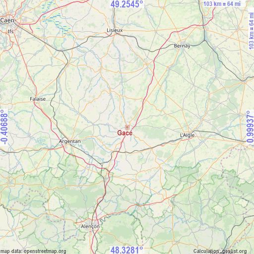
Gacé GPS coordinates[2]
48° 47' 36.384" North, 0° 17' 46.464" East
| Map corner | latitude | longitude |
|---|---|---|
| Upper-left | 49.2545°, | -0.40688° |
| Center: | 48.79344°, | 0.29624° |
| Lower-right: | 48.3281°, | 0.99937° |
| Map W x H: | 103×103 km | = 64×64mi |
| max Lat: | 51.07786° ⇑24.6% North |
| Gacé: | 48.79344° |
| min Lat: | ⇓75.4% South 41.3874° |
| min Long | Gacé | max Long |
| -5.08615° | 0.29624° | 9.52242° |
| W 24.6%⇐ | ⇒75.4% E |
Elevation
Elevation of Gacé is 198 m = 650 ft, and this is 4.3 m = 14 ft above average elevation for this country.
| Max E: |
2333 m = 7654 ft | 34.2% |
| Gacé | 198 m 650 ft | |
| Avg. | 193.7 m = 635 ft | |
Min E: |
-1 m = -3 ft | 65.8% |
See also: France elevation on elevation.city.
Geographical zone
Gacé is located in North temperate zone (between Tropic of Cancer and the Arctic Circle). Distance of this North polar circle is 1975.9 km =1227.8 mi to North.| Distance of | km | miles | from Gacé |
|---|---|---|---|
| North Pole | 4581.7 | 2846.9 | to North |
| Arctic Circle | 1975.9 | 1227.8 | to North |
| Tropic Cancer | 2819.4 | 1751.9 | to South |
| Equator | 5425.3 | 3371.1 | to South |


Nearby cities:
15 places around Gacé: (largest is in red/bold)
• Almenêches
17.4 km =10.8 mi,  231°
231°
• Aube-sur-Rîle
19.7 km =12.2 mi,  107°
107°
• Courtomer
19 km =11.8 mi,  166°
166°
• La Ferté-Frênel
16.6 km =10.3 mi,  71°
71°
• Le Merlerault
10.4 km =6.5 mi,  184°
184°
• Le Sap
11.6 km =7.2 mi,  15°
15°
• Montreuil-l'Argillé
21.1 km =13.1 mi,  39°
39°
• Moulins-la-Marche
20.6 km =12.8 mi,  140°
140°
• Nonant-le-Pin
11.2 km =7 mi,  209°
209°
• Saint-Symphorien-des-Bruyères
21 km =13 mi,  91°
91°
• Sainte-Gauburge-Sainte-Colombe
13 km =8.1 mi,  130°
130°
• Trun
20.1 km =12.5 mi,  285°
285°
• Urou-et-Crennes
20.9 km =13 mi,  257°
257°
• Vimoutiers
16.6 km =10.3 mi,  334°
334°
• Échauffour
8.9 km =5.5 mi, 131°
Sources, notices
• [Note1] Compared only with cities in France existing in our database
• [Src1] Map data: © OpenStreetMap contributors (CC-BY-SA)
• [Src2] Other city data from geonames.org with taken over terms of usage.
• [Src3] Geographical zone / Annual Mean Temperature by Robert A. Rohde @ Wikipedia
