Mazan geodata
Mazan (Provence-Alpes-Côte d'Azur) is a populated place; located in France in Europe/Paris (GMT+2) time zone. With population of 5,307 people, there are 1858 cities with bigger population in this country. Compared to other cities in France, 86.6% of cities are located further ↑North; 79% of cities are located further ←West and 56.1% of cities have lower elevation than Mazan. Note1
Administrative division(s):
- Level 1: Provence-Alpes-Côte d'Azur
- Level 2: Département du Vaucluse
- Level 3: Arrondissement de Carpentras
- Level 4: Mazan


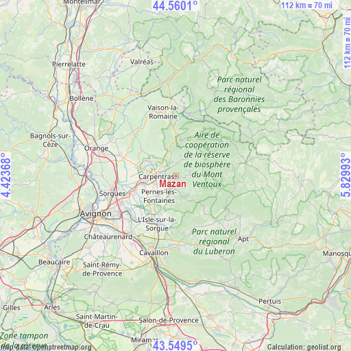
Mazan GPS coordinates[2]
44° 3' 25.056" North, 5° 7' 36.48" East
| Map corner | latitude | longitude |
|---|---|---|
| Upper-left | 44.5601°, | 4.42368° |
| Center: | 44.05696°, | 5.1268° |
| Lower-right: | 43.5495°, | 5.82993° |
| Map W x H: | 112.4×112.4 km | = 69.8×69.8mi |
| max Lat: | 51.07786° ⇑86.6% North |
| Mazan: | 44.05696° |
| min Lat: | ⇓13.4% South 41.3874° |
| min Long | Mazan | max Long |
| -5.08615° | 5.1268° | 9.52242° |
| W 79%⇐ | ⇒21% E |
Elevation
Elevation of Mazan is 154 m = 505 ft, and this is 39.7 m = 130 ft below average elevation for this country.
| Max E: |
2333 m = 7654 ft | 43.9% |
| Avg. | 193.7 m = 635 ft | |
| Mazan | 154 m = 505 ft | |
Min E: |
-1 m = -3 ft | 56.1% |
See also: France elevation on elevation.city.
Geographical zone
Mazan is located in North temperate zone (between Tropic of Cancer and the Arctic Circle). Distance of this Northern Tropic circle is 2292.8 km =1424.7 mi to South.| Distance of | km | miles | from Mazan |
|---|---|---|---|
| North Pole | 5108.4 | 3174.2 | to North |
| Arctic Circle | 2502.5 | 1555 | to North |
| Tropic Cancer | 2292.8 | 1424.7 | to South |
| Equator | 4898.7 | 3043.9 | to South |


Nearby cities:
15 places around Mazan: (largest is in red/bold)
• Aubignan
9.4 km =5.8 mi,  300°
300°
• Beaumes-de-Venise
10.6 km =6.6 mi,  313°
313°
• Bédoin
8.6 km =5.3 mi,  29°
29°
• Caromb
6.2 km =3.9 mi,  345°
345°
• Carpentras
6.3 km =3.9 mi,  268°
268°
• Le Barroux
9.1 km =5.7 mi, 346°
• Loriol-du-Comtat
10.3 km =6.4 mi,  282°
282°
• Malemort-du-Comtat
4.8 km =3 mi,  146°
146°
• Monteux
10.7 km =6.6 mi,  257°
257°
• Mormoiron
4.7 km =2.9 mi,  74°
74°
• Pernes-les-Fontaines
8.5 km =5.3 mi,  219°
219°
• Saint-Didier
6 km =3.7 mi,  192°
192°
• Sarrians
12.8 km =8 mi, 283°
• Venasque
7 km =4.3 mi,  166°
166°
• Villes-sur-Auzon
8.6 km =5.3 mi,  90°
90°
Sources, notices
• [Note1] Compared only with cities in France existing in our database
• [Src1] Map data: © OpenStreetMap contributors (CC-BY-SA)
• [Src2] Other city data from geonames.org with taken over terms of usage.
• [Src3] Geographical zone / Annual Mean Temperature by Robert A. Rohde @ Wikipedia
