Ézanville geodata
Ézanville (Île-de-France) is a populated place; located in France in Europe/Paris (GMT+2) time zone. With population of 8,950 people, there are 1076 cities with bigger population in this country. Compared to other cities in France, 80.4% of cities are located further ↓South; 51.5% of cities are located further →East and 68.7% of cities have higher elevation than Ézanville. Note1
Administrative division(s):
- Level 1: Île-de-France
- Level 2: Département du Val-d’Oise
- Level 3: Arrondissement de Sarcelles
- Level 4: Ézanville


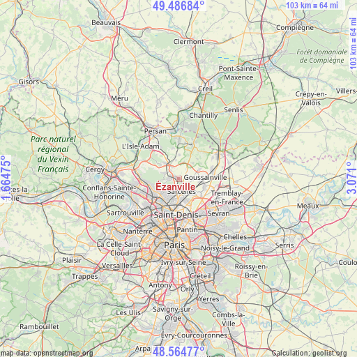
Ézanville GPS coordinates[2]
49° 1' 40.584" North, 2° 22' 4.332" East
| Map corner | latitude | longitude |
|---|---|---|
| Upper-left | 49.48684°, | 1.66475° |
| Center: | 49.02794°, | 2.36787° |
| Lower-right: | 48.56477°, | 3.071° |
| Map W x H: | 102.5×102.5 km | = 63.7×63.7mi |
| max Lat: | 51.07786° ⇑19.6% North |
| Ézanville: | 49.02794° |
| min Lat: | ⇓80.4% South 41.3874° |
| min Long | Ézanville | max Long |
| -5.08615° | 2.36787° | 9.52242° |
| W 48.5%⇐ | ⇒51.5% E |
Elevation
Elevation of Ézanville is 81 m = 266 ft, and this is 112.7 m = 370 ft below average elevation for this country.
| Max E: |
2333 m = 7654 ft | 68.7% |
| Avg. | 193.7 m = 635 ft | |
| Ézanville | 81 m = 266 ft | |
Min E: |
-1 m = -3 ft | 31.3% |
See also: France elevation on elevation.city.
Geographical zone
Ézanville is located in North temperate zone (between Tropic of Cancer and the Arctic Circle). Distance of this North polar circle is 1949.8 km =1211.5 mi to North.| Distance of | km | miles | from Ézanville |
|---|---|---|---|
| North Pole | 4555.7 | 2830.8 | to North |
| Arctic Circle | 1949.8 | 1211.5 | to North |
| Tropic Cancer | 2845.5 | 1768.1 | to South |
| Equator | 5451.4 | 3387.3 | to South |


Nearby cities:
15 places around Ézanville: (largest is in red/bold)
• Andilly
5.2 km =3.2 mi,  246°
246°
• Attainville
3.7 km =2.3 mi,  333°
333°
• Bouffémont
5.4 km =3.4 mi,  289°
289°
• Domont
3 km =1.9 mi,  269°
269°
• Groslay
4.9 km =3 mi,  197°
197°
• Le Mesnil-Aubry
3.5 km =2.2 mi,  40°
40°
• Margency
5.8 km =3.6 mi,  237°
237°
• Moisselles
3.4 km =2.1 mi,  316°
316°
• Montmorency
4.8 km =3 mi, 202°
• Piscop
2.4 km =1.5 mi,  223°
223°
• Saint-Brice-sous-Forêt
3.1 km =1.9 mi, 199°
• Sarcelles
3.5 km =2.2 mi,  167°
167°
• Villaines-sous-Bois
5.4 km =3.4 mi,  352°
352°
• Villiers-le-Bel
3.1 km =1.9 mi,  133°
133°
• Écouen
1.4 km =0.9 mi, 126°
Sources, notices
• [Note1] Compared only with cities in France existing in our database
• [Src1] Map data: © OpenStreetMap contributors (CC-BY-SA)
• [Src2] Other city data from geonames.org with taken over terms of usage.
• [Src3] Geographical zone / Annual Mean Temperature by Robert A. Rohde @ Wikipedia
