Chambost-Longessaigne geodata
Chambost-Longessaigne (Auvergne-Rhône-Alpes) is a populated place; located in France in Europe/Paris (GMT+2) time zone. With population of 760 people, there are 11054 cities with bigger population in this country. Compared to other cities in France, 69.7% of cities are located further ↑North; 71.1% of cities are located further ←West and 94.7% of cities have lower elevation than Chambost-Longessaigne. Note1
Administrative division(s):
- Level 1: Auvergne-Rhône-Alpes
- Level 2: Département du Rhône
- Level 3: Arrondissement de Lyon
- Level 4: Chambost-Longessaigne
Current local time in Chambost-Longessaigne:
03:19 PM, SaturdayDifference from your time zone: hours


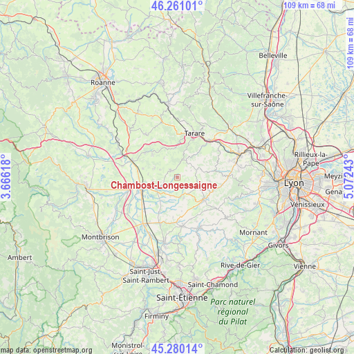
Chambost-Longessaigne GPS coordinates[2]
45° 46' 21.828" North, 4° 22' 9.48" East
| Map corner | latitude | longitude |
|---|---|---|
| Upper-left | 46.26101°, | 3.66618° |
| Center: | 45.77273°, | 4.3693° |
| Lower-right: | 45.28014°, | 5.07243° |
| Map W x H: | 109.1×109.1 km | = 67.8×67.8mi |
| max Lat: | 51.07786° ⇑69.7% North |
| Chambost-Longessaigne: | 45.77273° |
| min Lat: | ⇓30.3% South 41.3874° |
| min Long | Chambost-Longes | max Long |
| -5.08615° | 4.3693° | 9.52242° |
| W 71.1%⇐ | ⇒28.9% E |
Elevation
Elevation of Chambost-Longessaigne is 570 m = 1870 ft, and this is 376.3 m = 1235 ft above average elevation for this country.
| Max E: |
2333 m = 7654 ft | 5.3% |
| Chambost-Longessaigne | 570 m 1870 ft | |
| Avg. | 193.7 m = 635 ft | |
Min E: |
-1 m = -3 ft | 94.7% |
See also: France elevation on elevation.city.
Geographical zone
Chambost-Longessaigne is located in North temperate zone (between Tropic of Cancer and the Arctic Circle). Distance of this North polar circle is 2311.7 km =1436.4 mi to North.| Distance of | km | miles | from Chambost-Longessaigne |
|---|---|---|---|
| North Pole | 4917.6 | 3055.7 | to North |
| Arctic Circle | 2311.7 | 1436.4 | to North |
| Tropic Cancer | 2483.5 | 1543.2 | to South |
| Equator | 5089.5 | 3162.5 | to South |


Nearby cities:
15 places around Chambost-Longessaigne: (largest is in red/bold)
• Civens
9.2 km =5.7 mi,  274°
274°
• Cottance
5.8 km =3.6 mi,  292°
292°
• Haute-Rivoire
6.7 km =4.2 mi,  161°
161°
• Longessaigne
4.7 km =2.9 mi,  63°
63°
• Montrottier
7.8 km =4.8 mi,  75°
75°
• Panissières
3 km =1.9 mi,  314°
314°
• Rozier-en-Donzy
7.8 km =4.8 mi, 293°
• Saint-Barthélemy-Lestra
6.5 km =4 mi,  200°
200°
• Saint-Clément-les-Places
4.7 km =2.9 mi,  117°
117°
• Saint-Laurent-de-Chamousset
8.3 km =5.2 mi, 117°
• Saint-Martin-Lestra
6 km =3.7 mi,  190°
190°
• Souzy
9.7 km =6 mi,  140°
140°
• Valeille
8.8 km =5.5 mi,  215°
215°
• Villechenève
5.3 km =3.3 mi,  32°
32°
• Violay
9 km =5.6 mi,  355°
355°
Sources, notices
• [Note1] Compared only with cities in France existing in our database
• [Src1] Map data: © OpenStreetMap contributors (CC-BY-SA)
• [Src2] Other city data from geonames.org with taken over terms of usage.
• [Src3] Geographical zone / Annual Mean Temperature by Robert A. Rohde @ Wikipedia
