Claveyson geodata
Claveyson (Auvergne-Rhône-Alpes) is a populated place; located in France in Europe/Paris (GMT+2) time zone. With population of 750 people, there are 11167 cities with bigger population in this country. Compared to other cities in France, 77.7% of cities are located further ↑North; 76.9% of cities are located further ←West and 75.8% of cities have lower elevation than Claveyson. Note1
Administrative division(s):
- Level 1: Auvergne-Rhône-Alpes
- Level 2: Département de la Drôme
- Level 3: Arrondissement de Valence
- Level 4: Claveyson


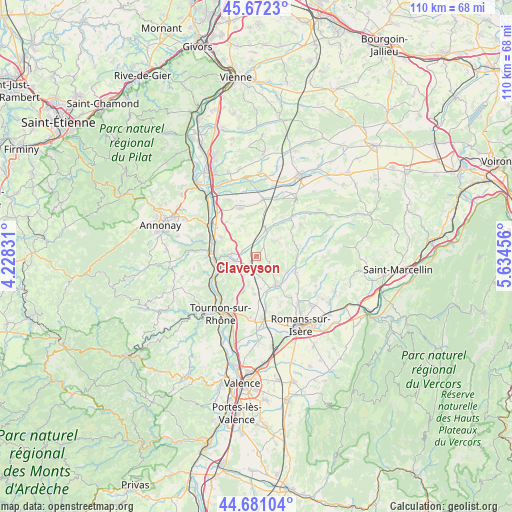
Claveyson GPS coordinates[2]
45° 10' 43.788" North, 4° 55' 53.148" East
| Map corner | latitude | longitude |
|---|---|---|
| Upper-left | 45.6723°, | 4.22831° |
| Center: | 45.17883°, | 4.93143° |
| Lower-right: | 44.68104°, | 5.63456° |
| Map W x H: | 110.2×110.2 km | = 68.5×68.5mi |
| max Lat: | 51.07786° ⇑77.7% North |
| Claveyson: | 45.17883° |
| min Lat: | ⇓22.3% South 41.3874° |
| min Long | Claveyson | max Long |
| -5.08615° | 4.93143° | 9.52242° |
| W 76.9%⇐ | ⇒23.1% E |
Elevation
Elevation of Claveyson is 255 m = 837 ft, and this is 61.3 m = 201 ft above average elevation for this country.
| Max E: |
2333 m = 7654 ft | 24.2% |
| Claveyson | 255 m 837 ft | |
| Avg. | 193.7 m = 635 ft | |
Min E: |
-1 m = -3 ft | 75.8% |
See also: France elevation on elevation.city.
Geographical zone
Claveyson is located in North temperate zone (between Tropic of Cancer and the Arctic Circle). Distance of this North polar circle is 2377.8 km =1477.5 mi to North.| Distance of | km | miles | from Claveyson |
|---|---|---|---|
| North Pole | 4983.6 | 3096.7 | to North |
| Arctic Circle | 2377.8 | 1477.5 | to North |
| Tropic Cancer | 2417.5 | 1502.2 | to South |
| Equator | 5023.4 | 3121.4 | to South |


Nearby cities:
15 places around Claveyson: (largest is in red/bold)
• Beausemblant
8.8 km =5.5 mi,  298°
298°
• Bren
4.8 km =3 mi,  165°
165°
• Chantemerle-les-Blés
7.5 km =4.7 mi,  201°
201°
• Châteauneuf-de-Galaure
6 km =3.7 mi,  20°
20°
• La Motte-de-Galaure
2.8 km =1.7 mi,  317°
317°
• Larnage
10.6 km =6.6 mi,  210°
210°
• Laveyron
9.4 km =5.8 mi,  291°
291°
• Margès
9.2 km =5.7 mi,  113°
113°
• Saint-Bardoux
10.5 km =6.5 mi,  161°
161°
• Saint-Barthélemy-de-Vals
4.8 km =3 mi,  257°
257°
• Saint-Uze
5.6 km =3.5 mi,  275°
275°
• Saint-Vallier
9 km =5.6 mi, 264°
• Sarras
10.3 km =6.4 mi,  274°
274°
• Serves-sur-Rhône
10.2 km =6.3 mi,  241°
241°
• Érôme
10.8 km =6.7 mi,  233°
233°
Sources, notices
• [Note1] Compared only with cities in France existing in our database
• [Src1] Map data: © OpenStreetMap contributors (CC-BY-SA)
• [Src2] Other city data from geonames.org with taken over terms of usage.
• [Src3] Geographical zone / Annual Mean Temperature by Robert A. Rohde @ Wikipedia
