La Motte-de-Galaure geodata
La Motte-de-Galaure (Auvergne-Rhône-Alpes) is a populated place; located in France in Europe/Paris (GMT+2) time zone. With population of 581 people, there are 13635 cities with bigger population in this country. Compared to other cities in France, 77.5% of cities are located further ↑North; 76.6% of cities are located further ←West and 67.6% of cities have lower elevation than La Motte-de-Galaure. Note1
Administrative division(s):
- Level 1: Auvergne-Rhône-Alpes
- Level 2: Département de la Drôme
- Level 3: Arrondissement de Valence
- Level 4: La Motte-de-Galaure


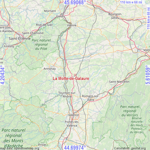
La Motte-de-Galaure GPS coordinates[2]
45° 11' 50.532" North, 4° 54' 26.856" East
| Map corner | latitude | longitude |
|---|---|---|
| Upper-left | 45.69068°, | 4.20434° |
| Center: | 45.19737°, | 4.90746° |
| Lower-right: | 44.69974°, | 5.61059° |
| Map W x H: | 110.2×110.2 km | = 68.5×68.5mi |
| max Lat: | 51.07786° ⇑77.5% North |
| La Motte-de-Galaure: | 45.19737° |
| min Lat: | ⇓22.5% South 41.3874° |
| min Long | La Motte-de-Gal | max Long |
| -5.08615° | 4.90746° | 9.52242° |
| W 76.6%⇐ | ⇒23.4% E |
Elevation
Elevation of La Motte-de-Galaure is 207 m = 679 ft, and this is 13.3 m = 44 ft above average elevation for this country.
| Max E: |
2333 m = 7654 ft | 32.4% |
| La Motte-de-Galaure | 207 m 679 ft | |
| Avg. | 193.7 m = 635 ft | |
Min E: |
-1 m = -3 ft | 67.6% |
See also: France elevation on elevation.city.
Geographical zone
La Motte-de-Galaure is located in North temperate zone (between Tropic of Cancer and the Arctic Circle). Distance of this North polar circle is 2375.7 km =1476.2 mi to North.| Distance of | km | miles | from La Motte-de-Galaure |
|---|---|---|---|
| North Pole | 4981.6 | 3095.4 | to North |
| Arctic Circle | 2375.7 | 1476.2 | to North |
| Tropic Cancer | 2419.6 | 1503.5 | to South |
| Equator | 5025.5 | 3122.7 | to South |


Nearby cities:
15 places around La Motte-de-Galaure: (largest is in red/bold)
• Andance
9.7 km =6 mi,  299°
299°
• Andancette
9.6 km =6 mi,  306°
306°
• Anneyron
8.5 km =5.3 mi,  348°
348°
• Beausemblant
6.3 km =3.9 mi,  290°
290°
• Bren
7.4 km =4.6 mi,  155°
155°
• Chantemerle-les-Blés
9.1 km =5.7 mi,  185°
185°
• Châteauneuf-de-Galaure
5.3 km =3.3 mi,  47°
47°
• Claveyson
2.8 km =1.7 mi,  137°
137°
• Laveyron
7 km =4.3 mi,  281°
281°
• Saint-Barthélemy-de-Vals
4.2 km =2.6 mi,  222°
222°
• Saint-Uze
4 km =2.5 mi,  248°
248°
• Saint-Vallier
7.6 km =4.7 mi, 247°
• Sarras
8.5 km =5.3 mi,  262°
262°
• Serves-sur-Rhône
9.9 km =6.2 mi,  225°
225°
• Talencieux
10.5 km =6.5 mi, 284°
Sources, notices
• [Note1] Compared only with cities in France existing in our database
• [Src1] Map data: © OpenStreetMap contributors (CC-BY-SA)
• [Src2] Other city data from geonames.org with taken over terms of usage.
• [Src3] Geographical zone / Annual Mean Temperature by Robert A. Rohde @ Wikipedia
