Ambon geodata
Ambon (Brittany) is a populated place; located in France in Europe/Paris (GMT+2) time zone. With population of 1,341 people, there are 6861 cities with bigger population in this country. Compared to other cities in France, 52.1% of cities are located further ↓South; 96.4% of cities are located further →East and 95.4% of cities have higher elevation than Ambon. Note1
Administrative division(s):
- Level 1: Brittany
- Level 2: Morbihan
- Level 3: Arrondissement de Vannes
- Level 4: Ambon


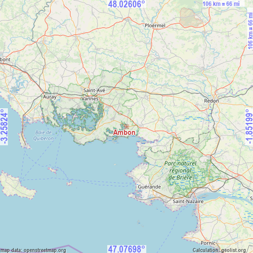
Ambon GPS coordinates[2]
47° 33' 13.212" North, 2° 33' 18.432" West
| Map corner | latitude | longitude |
|---|---|---|
| Upper-left | 48.02606°, | -3.25824° |
| Center: | 47.55367°, | -2.55512° |
| Lower-right: | 47.07698°, | -1.85199° |
| Map W x H: | 105.5×105.5 km | = 65.6×65.6mi |
| max Lat: | 51.07786° ⇑47.9% North |
| Ambon: | 47.55367° |
| min Lat: | ⇓52.1% South 41.3874° |
| min Long | Ambon | max Long |
| -5.08615° | -2.55512° | 9.52242° |
| W 3.6%⇐ | ⇒96.4% E |
Elevation
Elevation of Ambon is 16 m = 52 ft, and this is 177.7 m = 583 ft below average elevation for this country.
| Max E: |
2333 m = 7654 ft | 95.4% |
| Avg. | 193.7 m = 635 ft | |
| Ambon | 16 m = 52 ft | |
Min E: |
-1 m = -3 ft | 4.6% |
See also: France elevation on elevation.city.
Geographical zone
Ambon is located in North temperate zone (between Tropic of Cancer and the Arctic Circle). Distance of this North polar circle is 2113.7 km =1313.4 mi to North.| Distance of | km | miles | from Ambon |
|---|---|---|---|
| North Pole | 4719.6 | 2932.6 | to North |
| Arctic Circle | 2113.7 | 1313.4 | to North |
| Tropic Cancer | 2681.6 | 1666.3 | to South |
| Equator | 5287.5 | 3285.5 | to South |


Nearby cities:
15 places around Ambon: (largest is in red/bold)
• Berric
9.2 km =5.7 mi,  15°
15°
• Billiers
5.7 km =3.5 mi,  116°
116°
• Damgan
4.3 km =2.7 mi,  202°
202°
• La Trinité-Surzur
6.3 km =3.9 mi,  333°
333°
• Lauzach
6.8 km =4.2 mi,  7°
7°
• Le Guerno
11.5 km =7.1 mi,  73°
73°
• Le Hézo
11.6 km =7.2 mi,  287°
287°
• Le Tour-du-Parc
7.5 km =4.7 mi,  245°
245°
• Muzillac
5.6 km =3.5 mi,  89°
89°
• Noyal-Muzillac
8.6 km =5.3 mi,  60°
60°
• Noyalo
11.1 km =6.9 mi,  304°
304°
• Pénestin
10.1 km =6.3 mi,  142°
142°
• Saint-Armel
11.8 km =7.3 mi,  280°
280°
• Surzur
6.2 km =3.9 mi, 296°
• Theix
11.1 km =6.9 mi,  319°
319°
Sources, notices
• [Note1] Compared only with cities in France existing in our database
• [Src1] Map data: © OpenStreetMap contributors (CC-BY-SA)
• [Src2] Other city data from geonames.org with taken over terms of usage.
• [Src3] Geographical zone / Annual Mean Temperature by Robert A. Rohde @ Wikipedia
