Les Eyzies-de-Tayac-Sireuil geodata
Les Eyzies-de-Tayac-Sireuil (Nouvelle-Aquitaine) is a populated place; located in France in Europe/Paris (GMT+2) time zone. With population of 909 people, there are 9582 cities with bigger population in this country. Compared to other cities in France, 80.2% of cities are located further ↑North; 68.7% of cities are located further →East and 73.6% of cities have higher elevation than Les Eyzies-de-Tayac-Sireuil. Note1
Administrative division(s):
- Level 1: Nouvelle-Aquitaine
- Level 2: Dordogne
- Level 3: Arrondissement de Sarlat-la-Canéda
- Level 4: Les Eyzies
Current local time in Les Eyzies-de-Tayac-Sireuil:
11:51 AM, SaturdayDifference from your time zone: hours


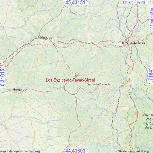
Les Eyzies-de-Tayac-Sireuil GPS coordinates[2]
44° 56' 9.348" North, 1° 0' 47.772" East
| Map corner | latitude | longitude |
|---|---|---|
| Upper-left | 45.43151°, | 0.31015° |
| Center: | 44.93593°, | 1.01327° |
| Lower-right: | 44.43603°, | 1.7164° |
| Map W x H: | 110.7×110.7 km | = 68.8×68.8mi |
| max Lat: | 51.07786° ⇑80.2% North |
| Les Eyzies-de-Tayac-Sireuil: | 44.93593° |
| min Lat: | ⇓19.8% South 41.3874° |
| min Long | Les Eyzies-de-T | max Long |
| -5.08615° | 1.01327° | 9.52242° |
| W 31.3%⇐ | ⇒68.7% E |
Elevation
Elevation of Les Eyzies-de-Tayac-Sireuil is 70 m = 230 ft, and this is 123.7 m = 406 ft below average elevation for this country.
| Max E: |
2333 m = 7654 ft | 73.6% |
| Avg. | 193.7 m = 635 ft | |
| Les Eyzies-de-Tayac-Sireuil | 70 m = 230 ft | |
Min E: |
-1 m = -3 ft | 26.4% |
See also: France elevation on elevation.city.
Geographical zone
Les Eyzies-de-Tayac-Sireuil is located in North temperate zone (between Tropic of Cancer and the Arctic Circle). Distance of this Northern Tropic circle is 2390.5 km =1485.4 mi to South.| Distance of | km | miles | from Les Eyzies-de-Tayac-Sireuil |
|---|---|---|---|
| North Pole | 5010.7 | 3113.5 | to North |
| Arctic Circle | 2404.8 | 1494.3 | to North |
| Tropic Cancer | 2390.5 | 1485.4 | to South |
| Equator | 4996.4 | 3104.6 | to South |


Nearby cities:
15 places around Les Eyzies-de-Tayac-Sireuil: (largest is in red/bold)
• Beynac-et-Cazenac
14.8 km =9.2 mi,  136°
136°
• Cendrieux
16.3 km =10.1 mi,  294°
294°
• Coux-et-Bigaroque
11.8 km =7.3 mi,  195°
195°
• Le Bugue
7.1 km =4.4 mi,  254°
254°
• Le Buisson-de-Cadouin
12.2 km =7.6 mi,  218°
218°
• Marquay
10.9 km =6.8 mi,  81°
81°
• Plazac
11.2 km =7 mi,  11°
11°
• Proissans
17.3 km =10.7 mi,  90°
90°
• Rouffignac-Saint-Cernin-de-Reilhac
13.2 km =8.2 mi,  343°
343°
• Saint-Cyprien
7.7 km =4.8 mi,  163°
163°
• Sainte-Alvère
15.6 km =9.7 mi,  275°
275°
• Sarlat-la-Canéda
16.8 km =10.4 mi,  108°
108°
• Siorac-en-Périgord
12.9 km =8 mi,  189°
189°
• Trémolat
15.9 km =9.9 mi,  244°
244°
• Vézac
16.5 km =10.3 mi,  133°
133°
Sources, notices
• [Note1] Compared only with cities in France existing in our database
• [Src1] Map data: © OpenStreetMap contributors (CC-BY-SA)
• [Src2] Other city data from geonames.org with taken over terms of usage.
• [Src3] Geographical zone / Annual Mean Temperature by Robert A. Rohde @ Wikipedia
