Chevroux geodata
Chevroux (Auvergne-Rhône-Alpes) is a populated place; located in France in Europe/Paris (GMT+2) time zone. With population of 721 people, there are 11522 cities with bigger population in this country. Compared to other cities in France, 61.3% of cities are located further ↑North; 77.2% of cities are located further ←West and 64.4% of cities have lower elevation than Chevroux. Note1
Administrative division(s):
- Level 1: Auvergne-Rhône-Alpes
- Level 2: Département de l'Ain
- Level 3: Arrondissement de Bourg-en-Bresse
- Level 4: Chevroux


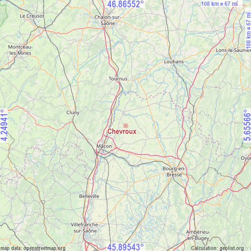
Chevroux GPS coordinates[2]
46° 22' 57.468" North, 4° 57' 9.144" East
| Map corner | latitude | longitude |
|---|---|---|
| Upper-left | 46.86552°, | 4.24941° |
| Center: | 46.38263°, | 4.95254° |
| Lower-right: | 45.89543°, | 5.65566° |
| Map W x H: | 107.9×107.9 km | = 67×67mi |
| max Lat: | 51.07786° ⇑61.3% North |
| Chevroux: | 46.38263° |
| min Lat: | ⇓38.7% South 41.3874° |
| min Long | Chevroux | max Long |
| -5.08615° | 4.95254° | 9.52242° |
| W 77.2%⇐ | ⇒22.8% E |
Elevation
Elevation of Chevroux is 191 m = 627 ft, and this is 2.7 m = 9 ft below average elevation for this country.
| Max E: |
2333 m = 7654 ft | 35.6% |
| Avg. | 193.7 m = 635 ft | |
| Chevroux | 191 m = 627 ft | |
Min E: |
-1 m = -3 ft | 64.4% |
See also: France elevation on elevation.city.
Geographical zone
Chevroux is located in North temperate zone (between Tropic of Cancer and the Arctic Circle). Distance of this North polar circle is 2243.9 km =1394.3 mi to North.| Distance of | km | miles | from Chevroux |
|---|---|---|---|
| North Pole | 4849.8 | 3013.5 | to North |
| Arctic Circle | 2243.9 | 1394.3 | to North |
| Tropic Cancer | 2551.3 | 1585.3 | to South |
| Equator | 5157.3 | 3204.6 | to South |


Nearby cities:
15 places around Chevroux: (largest is in red/bold)
• Bâgé-la-Ville
7.5 km =4.7 mi,  186°
186°
• Bâgé-le-Châtel
8.3 km =5.2 mi, 191°
• Chavannes-sur-Reyssouze
6.4 km =4 mi,  32°
32°
• Feillens
7.1 km =4.4 mi,  221°
221°
• Gorrevod
4.1 km =2.5 mi,  352°
352°
• Manziat
4.3 km =2.7 mi,  236°
236°
• Ozan
3 km =1.9 mi,  287°
287°
• Pont-de-Vaux
5.7 km =3.5 mi, 353°
• Reyssouze
6.3 km =3.9 mi,  337°
337°
• Saint-Albain
7.8 km =4.8 mi,  310°
310°
• Saint-André-de-Bâgé
9.3 km =5.8 mi, 193°
• Saint-Bénigne
6.5 km =4 mi,  13°
13°
• Saint-Jean-sur-Reyssouze
8.5 km =5.3 mi,  80°
80°
• Saint-Martin-Belle-Roche
7.5 km =4.7 mi,  270°
270°
• Senozan
7 km =4.3 mi,  282°
282°
Sources, notices
• [Note1] Compared only with cities in France existing in our database
• [Src1] Map data: © OpenStreetMap contributors (CC-BY-SA)
• [Src2] Other city data from geonames.org with taken over terms of usage.
• [Src3] Geographical zone / Annual Mean Temperature by Robert A. Rohde @ Wikipedia
