Saint-Bénigne geodata
Saint-Bénigne (Auvergne-Rhône-Alpes) is a populated place; located in France in Europe/Paris (GMT+2) time zone. With population of 910 people, there are 9574 cities with bigger population in this country. Compared to other cities in France, 60.6% of cities are located further ↑North; 77.4% of cities are located further ←West and 68.1% of cities have lower elevation than Saint-Bénigne. Note1
Administrative division(s):
- Level 1: Auvergne-Rhône-Alpes
- Level 2: Département de l'Ain
- Level 3: Arrondissement de Bourg-en-Bresse
- Level 4: Saint-Bénigne


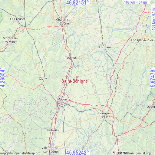
Saint-Bénigne GPS coordinates[2]
46° 26' 20.832" North, 4° 58' 18.012" East
| Map corner | latitude | longitude |
|---|---|---|
| Upper-left | 46.92151°, | 4.26854° |
| Center: | 46.43912°, | 4.97167° |
| Lower-right: | 45.95242°, | 5.67479° |
| Map W x H: | 107.8×107.8 km | = 67×67mi |
| max Lat: | 51.07786° ⇑60.6% North |
| Saint-Bénigne: | 46.43912° |
| min Lat: | ⇓39.4% South 41.3874° |
| min Long | Saint-Bénigne | max Long |
| -5.08615° | 4.97167° | 9.52242° |
| W 77.4%⇐ | ⇒22.6% E |
Elevation
Elevation of Saint-Bénigne is 210 m = 689 ft, and this is 16.3 m = 53 ft above average elevation for this country.
| Max E: |
2333 m = 7654 ft | 31.9% |
| Saint-Bénigne | 210 m 689 ft | |
| Avg. | 193.7 m = 635 ft | |
Min E: |
-1 m = -3 ft | 68.1% |
See also: France elevation on elevation.city.
Geographical zone
Saint-Bénigne is located in North temperate zone (between Tropic of Cancer and the Arctic Circle). Distance of this North polar circle is 2237.6 km =1390.4 mi to North.| Distance of | km | miles | from Saint-Bénigne |
|---|---|---|---|
| North Pole | 4843.5 | 3009.6 | to North |
| Arctic Circle | 2237.6 | 1390.4 | to North |
| Tropic Cancer | 2557.6 | 1589.2 | to South |
| Equator | 5163.5 | 3208.4 | to South |


Nearby cities:
15 places around Saint-Bénigne: (largest is in red/bold)
• Chavannes-sur-Reyssouze
2.1 km =1.3 mi,  114°
114°
• Chevroux
6.5 km =4 mi,  193°
193°
• Gorrevod
3 km =1.9 mi,  221°
221°
• Manziat
10 km =6.2 mi,  210°
210°
• Montbellet
8.6 km =5.3 mi,  298°
298°
• Ozan
6.9 km =4.3 mi, 218°
• Pont-de-Vaux
2.2 km =1.4 mi,  252°
252°
• Reyssouze
3.9 km =2.4 mi,  263°
263°
• Saint-Albain
7.5 km =4.7 mi, 260°
• Saint-Jean-sur-Reyssouze
8.4 km =5.2 mi,  124°
124°
• Saint-Trivier-de-Courtes
8.4 km =5.2 mi,  74°
74°
• Senozan
9.6 km =6 mi,  240°
240°
• Sermoyer
6.7 km =4.2 mi,  4°
4°
• Uchizy
9.7 km =6 mi,  317°
317°
• Viré
9.9 km =6.2 mi,  277°
277°
Sources, notices
• [Note1] Compared only with cities in France existing in our database
• [Src1] Map data: © OpenStreetMap contributors (CC-BY-SA)
• [Src2] Other city data from geonames.org with taken over terms of usage.
• [Src3] Geographical zone / Annual Mean Temperature by Robert A. Rohde @ Wikipedia
