Goudargues geodata
Goudargues (Occitanie) is a populated place; located in France in Europe/Paris (GMT+2) time zone. With population of 1,031 people, there are 8609 cities with bigger population in this country. Compared to other cities in France, 85.4% of cities are located further ↑North; 71.8% of cities are located further ←West and 67.4% of cities have higher elevation than Goudargues. Note1
Administrative division(s):
- Level 1: Occitanie
- Level 2: Gard
- Level 3: Arrondissement de Nîmes
- Level 4: Goudargues


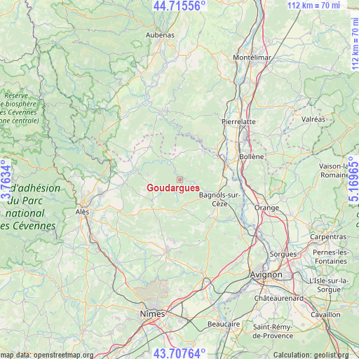
Goudargues GPS coordinates[2]
44° 12' 49.536" North, 4° 27' 59.472" East
| Map corner | latitude | longitude |
|---|---|---|
| Upper-left | 44.71556°, | 3.7634° |
| Center: | 44.21376°, | 4.46652° |
| Lower-right: | 43.70764°, | 5.16965° |
| Map W x H: | 112.1×112.1 km | = 69.7×69.7mi |
| max Lat: | 51.07786° ⇑85.4% North |
| Goudargues: | 44.21376° |
| min Lat: | ⇓14.6% South 41.3874° |
| min Long | Goudargues | max Long |
| -5.08615° | 4.46652° | 9.52242° |
| W 71.8%⇐ | ⇒28.2% E |
Elevation
Elevation of Goudargues is 84 m = 276 ft, and this is 109.7 m = 360 ft below average elevation for this country.
| Max E: |
2333 m = 7654 ft | 67.4% |
| Avg. | 193.7 m = 635 ft | |
| Goudargues | 84 m = 276 ft | |
Min E: |
-1 m = -3 ft | 32.6% |
See also: France elevation on elevation.city.
Geographical zone
Goudargues is located in North temperate zone (between Tropic of Cancer and the Arctic Circle). Distance of this Northern Tropic circle is 2310.2 km =1435.5 mi to South.| Distance of | km | miles | from Goudargues |
|---|---|---|---|
| North Pole | 5091 | 3163.4 | to North |
| Arctic Circle | 2485.1 | 1544.2 | to North |
| Tropic Cancer | 2310.2 | 1435.5 | to South |
| Equator | 4916.1 | 3054.7 | to South |


Nearby cities:
15 places around Goudargues: (largest is in red/bold)
• Bagnols-sur-Cèze
13.5 km =8.4 mi,  116°
116°
• Barjac
13.9 km =8.6 mi,  318°
318°
• Carsan
10.5 km =6.5 mi,  77°
77°
• Cavillargues
11.9 km =7.4 mi,  158°
158°
• Cornillon
2.2 km =1.4 mi,  57°
57°
• Pont-Saint-Esprit
15.1 km =9.4 mi,  72°
72°
• Sabran
9.6 km =6 mi,  137°
137°
• Saint-Alexandre
12.4 km =7.7 mi, 82°
• Saint-Gervais
9.3 km =5.8 mi,  111°
111°
• Saint-Jean-de-Maruéjols-et-Avéjan
14.5 km =9 mi,  289°
289°
• Saint-Julien-de-Peyrolas
11.4 km =7.1 mi,  43°
43°
• Saint-Laurent-la-Vernède
12 km =7.5 mi,  182°
182°
• Saint-Marcel-de-Careiret
8.3 km =5.2 mi,  168°
168°
• Saint-Nazaire
12.7 km =7.9 mi,  97°
97°
• Saint-Paulet-de-Caisson
11.7 km =7.3 mi, 63°
Sources, notices
• [Note1] Compared only with cities in France existing in our database
• [Src1] Map data: © OpenStreetMap contributors (CC-BY-SA)
• [Src2] Other city data from geonames.org with taken over terms of usage.
• [Src3] Geographical zone / Annual Mean Temperature by Robert A. Rohde @ Wikipedia
